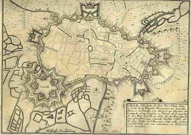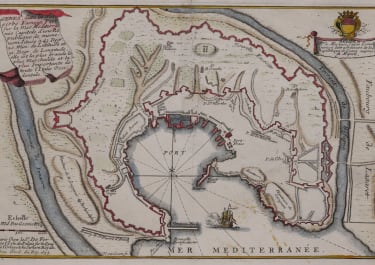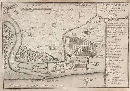
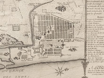
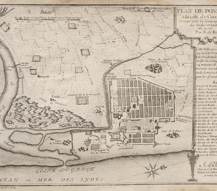
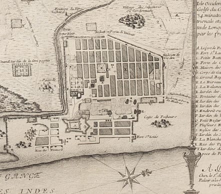
PLAN DE PONDICHERRY A LA COTE DE COROMANDEL
Sold
Superb plan of Pondicherry or Puducherry as it was cica 1700. Enlightened layout incomplete , not finished until mid century.
Comprehensive legend covering all main buildings as of 1700.
Since 1674, Pondicherry had served as the epicentre of French operations in India and even today it retains a strong French influence ( my blog on Pondicherry
https://mickjennings.wordpress.com/2015/10/28/pondicherry-a-beautiful-city-and-scandals-at-aurobindo-ashram/ )
Uncommon map
Uncoloured as issued
Very good condition
References: OCLC: 494248975. Cf. Vivek Nanda & Alexander Johnson, Cosmology to Cartography: A Cultural Journey of Indian Maps (New Delhi, 2015), pp. 238-43, A.M. Muthu, ‘The Urbanization of Pondicherry during the French Colonial rule from 1673 to 1816’ (Ph.D. Thesis, University of Pondicherry, 2002).
code : M4200
Cartographer : DE FER Nicolas
Date : 1705
Size : 26.5*39 cms
availability : Sold
Price : Sold
Nicolas de Fer (1646-1720) was the son of Antoine de Fer, also a map engraver and colourist in his own right who had worked with Nicolas Berey and acted as an editor for Pierre Duval's "Cartes De Geographie ..." of 1657. However, it was Nicolas who was to become one of the most prolific publishers of his time.
De Fer was able to make the publishing business flourish and in 1690 he was nominated as geographer to the Dauphin - their relationship had reciprocal benefits with De Fer producing, in effect, royal propaganda concerning the Dauphin's lands with each publication enhancing his own name and reputation, as well as that of the Dauphin. When the Duke of Anjou ascended the throne in 1702, De Fer had the dual title of "geographe du roi d'Espagne et du Dauphin".
De Fer published a number of atlases including the "Cotes de France" of 1690 (containing Tassin's maps) and the "Forces de l'Europe ou Introduction a la fortification", also of 1690, that reinforced his abilities and success with the buying public. Subsequent publications included the "Petit et Nouveau Atlas", which appeared in 1697, followed by the "Atlas Curieux". The "Atlas Curieux" was well-known and popular, being expanded in successive editions between 1700 and 1705, and was re-edited in 1714 and 1716 under the title "Suite de l'Atlas Curieux". De Fer also produced a number of folio maps that appeared in the "Atlas ou Recueil de cartes", which was published in 1709.