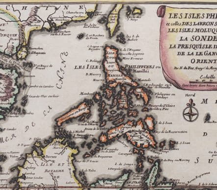
LES ISLES PHILIPINNES ET CELLES DES LARONS LES ISLES MOLUQUES..
£335
Full Title : Les Isles Philippines et celles Des Larrons ou de Marianes, Les Isles Moluques et de La Sonde, avec, La Presqu'Isle de l'Inde de la le Gange ou Orientale.
Rare and stunning map of Philippiners , East Indies Java, Sumartra etc and a very interesting coastline of Cambodia and Vietnam.
Cartouche.
Excellent hand colour
Mint condition
Publication Atlas Curieux
code : M4431
Cartographer : DE FER Nicolas
Date : 1702 Paris
Size : 22.5*34 cms
availability : Available
Price : £335
Nicolas de Fer (1646-1720) was the son of Antoine de Fer, also a map engraver and colourist in his own right who had worked with Nicolas Berey and acted as an editor for Pierre Duval's "Cartes De Geographie ..." of 1657. However, it was Nicolas who was to become one of the most prolific publishers of his time.
De Fer was able to make the publishing business flourish and in 1690 he was nominated as geographer to the Dauphin - their relationship had reciprocal benefits with De Fer producing, in effect, royal propaganda concerning the Dauphin's lands with each publication enhancing his own name and reputation, as well as that of the Dauphin. When the Duke of Anjou ascended the throne in 1702, De Fer had the dual title of "geographe du roi d'Espagne et du Dauphin".
De Fer published a number of atlases including the "Cotes de France" of 1690 (containing Tassin's maps) and the "Forces de l'Europe ou Introduction a la fortification", also of 1690, that reinforced his abilities and success with the buying public. Subsequent publications included the "Petit et Nouveau Atlas", which appeared in 1697, followed by the "Atlas Curieux". The "Atlas Curieux" was well-known and popular, being expanded in successive editions between 1700 and 1705, and was re-edited in 1714 and 1716 under the title "Suite de l'Atlas Curieux". De Fer also produced a number of folio maps that appeared in the "Atlas ou Recueil de cartes", which was published in 1709.