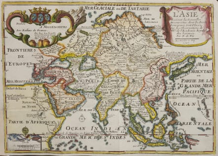
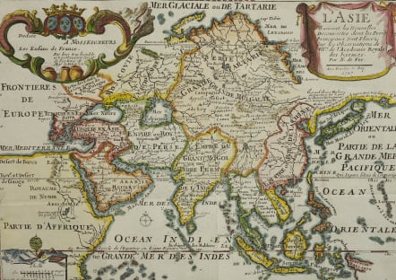
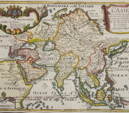
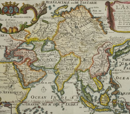
L'ASIE SUIVANT LES NOUVELLES DECOUVERTES
Sold
An attractive, interesting and very unusual map of all of Asia from Nicholas de Fer's L'Atlas Curieux ou le Monde. This example is the third state, dated 1717.
The map is based primarily on Dutch sources, particularly the outlines of Siberia and the East Indies. However, the most striking feature, which is original to De Fer, is a continuous landbridge extending from northern Korea and eastern Siberia across to America. A note acknowledges Portuguese sources for this new portrayal of the region. Hokkaido (Ieso) appears as a small circular island north of Japan. The northern coastline of Asia is based on Witsen's explorations including Cap Tabin and Cap Glace. The interior is filled with details, including what appears to be a road from Moscow to Peking, and the Great Wall of China. The Caspian Sea is presented in an unusual shape. India is misshapen and the coastline of a portion of New Guinea is incorrectly named as "Nouvelle Zeelande."
Excellent hand colour
Very good condition
code : M4838
Cartographer : DE FER Nicolas
Date : 1717 Paris
Size : 23*32.5 cms
availability : Sold
Price : Sold
Nicolas de Fer (1646-1720) was the son of Antoine de Fer, also a map engraver and colourist in his own right who had worked with Nicolas Berey and acted as an editor for Pierre Duval's "Cartes De Geographie ..." of 1657. However, it was Nicolas who was to become one of the most prolific publishers of his time.
De Fer was able to make the publishing business flourish and in 1690 he was nominated as geographer to the Dauphin - their relationship had reciprocal benefits with De Fer producing, in effect, royal propaganda concerning the Dauphin's lands with each publication enhancing his own name and reputation, as well as that of the Dauphin. When the Duke of Anjou ascended the throne in 1702, De Fer had the dual title of "geographe du roi d'Espagne et du Dauphin".
De Fer published a number of atlases including the "Cotes de France" of 1690 (containing Tassin's maps) and the "Forces de l'Europe ou Introduction a la fortification", also of 1690, that reinforced his abilities and success with the buying public. Subsequent publications included the "Petit et Nouveau Atlas", which appeared in 1697, followed by the "Atlas Curieux". The "Atlas Curieux" was well-known and popular, being expanded in successive editions between 1700 and 1705, and was re-edited in 1714 and 1716 under the title "Suite de l'Atlas Curieux". De Fer also produced a number of folio maps that appeared in the "Atlas ou Recueil de cartes", which was published in 1709.