SEA CHART THE CAPE PLAN DU CAP DE BONNE-ESPERENCE ET DES ENVIRONS
Sold
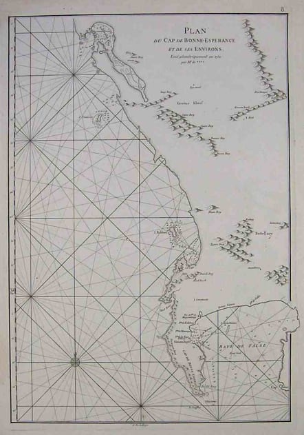
Superb French chart of Cape of Good Hope.
Latitude and longitude scales, compass rose and system of rhumb lines, soundings near coast and in bay areas.
D' Après de Mannevillette (1707-1780) was a famous French sailor and hydrograph. During a voyage to China in 1728 he succeeded in correcting the latitudes of many places using new instruments. Back in France he devised a plan to correct and publish all the existing maps of the route to China: the Res Sea, the coasts of India, Malaya, the northern parts of Indonesia, Indochina and China.
When the first edition of his Atlas Le Neptune Oriental (containing only 22 charts) was published in 1745, it was regarded as a major achievement and a library indispensable to navigators. In 1672, d'Après was appointed director of an office established by the Compagnie des Indes for the publication of charts.
Printed on heavy paper.
Mint condition.
code : M2186
Cartographer : MANNEVILLETTE Jean Baptiste
Date : 1775c Paris
Size : 48*33cms
availability : Sold
Price : Sold
Jean Baptiste Mannevillette (*1707 - †1780)
"During many subsequent voyages he [Jean Baptiste Nicolas Denis d'Après de Mannevillette] assembled a collection of material for a projected hydrographic atlas which, with the support of Académie des Sciences, was published in Paris in 1745 under the title Le Neptune Oriental. In spite of the popularity of the first issue, it failed to satisfy the author and he spent nearly thirty years, often with the assistance of his friend, Alexander Dalrymple, the English hydrographer, in the preparation of the revised and enlarged edition which eventually was issued in 1775." (Antique Maps, Moreland & Bannister)
