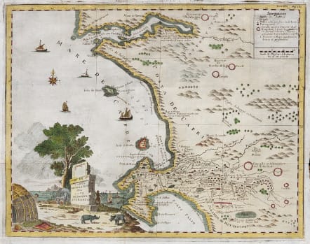
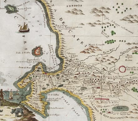
CARTA GEOGRAFICA DEL CAPO DI BUONA SPERANZA
Sold
This attractive, uncommon map with a beautiful vignette depicts the second early expansion of the Cape of Good Hope Settlement beyond The Castle and Liesbeeck River. The map is historically important because of the names some of the early settlers and their farms.
The map was published in 1750 in Albrizzi's Atlante Novissimo Del Sig. Guglielmo De L'Isle; the title of the atlas led to the map being incorrectly attributed to the famous French cartographer Guillaume Delisle.
Carta geographica del Capo di Bona Speranza first was published in 1740; the map on offer came from the 2nd edition of the Atlante Novissimo (1750). The engraver is not known, but, according to Scholte, the first edition of the Atlante Novissimo (1740) indicated that most of the maps were engraved by Isaac Tirion; unfortunately, the only known copy of the first edition of the atlas was lost during the 1966 flood of the Arno River in Florence.
In fact, the map is similar to a smaller map by Pieter Van der Aa: Le Cap de Bonne Esperance. Both maps are derived from a 1690 manuscript map produced by the VOC.
Good and colour
Very good condition
code : M5038
Cartographer : Albrizzi Giovani
Date : 1740
Size : 33*43 cms
availability : Sold
Price : Sold
Although Venice had been the centre of the European map-trade in the 1550s, its importance had been subsequently eclipsed by Antwerp and then Amsterdam in the late sixteenth and seventeenth centuries. So it was from Amsterdam that Giovanni Battista (Giovambattista) Albrizzi, the Italian, took inspiration for his best-known atlas - the Nieuwe En Beknopte Handatlas ... by Isaak Tirion was translated into Italian and published in Venice by Albrizzi. Albrizzi was also responsible for publishing an edition of Guillaume De L'Isle's atlas as Atlante Novissimo.