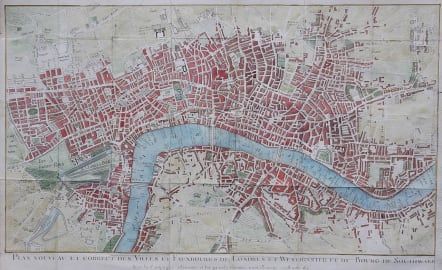
LONDON PLAN NOUVEAU ET CORRECT DES VILLES ET FAUXBOURGS DE LONDRES ET WESTMINSTER ET DU BOURG DE SOUTHWARK
Sold
Full title: Plan nouveau et correct des villes et fauxbourgs de Londres et Westminster et du bourg de Southwark avec la campagne adjacente, et les grands chemins nouvellement construits &c
Very rare map of London. I have found only one example of map at Berne University Library. Folds as issued.Part of Oxford Street called Tyburn Road.
Interesting depiction of London in the middle of Eighteenth century just before it grew rapidly.
Excellent hand colour, small repair barely noticeable otherwise very good condition.
http://www.europeana.eu/portal/record/9200109/5C68FA9CAA60FBC4416B3B1CEA63E14385461E2D.html
code : M2733
Cartographer : ROUGE LE Georges-Louis
Date : 1770c Paris
Size : 30*49 cms
availability : Sold
Price : Sold
Lieutenant George-Louis Le ROUGE
Lieutenant George-Louis Le Rouge (c.1712-c.1790) was born in Hanover, Germany. He became a Lieutenant in the regiment of Saxe before establishing himself as a publisher, compiler and editor of maps in Paris. He later became the “Ingenieur Geographe de Roi”.
Le Rouge is particularly known for such atlas works as the “Atlas Nouveau” of 1746 and the “Atlas Nouveau Portatif ...” or the “Introduction A La Geographie” of 1756 – French publications of some merit.
Le Rouge was initially a military “Ingenieur” for fortifications and he was also a map-maker for the army and Marine Royale. He was active between 1740 and 1780, in Paris at, rue des Augustins.