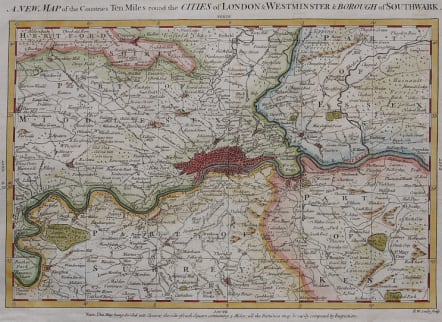
A NEW MAP OF THE COUNTRIES TEN MILES ROUND THE CITIES OF LONDON & WESTMINSTER & BOROUGH OF SOUTHWARK
Sold
Very attractive map of London by Richard Seale, published with Stow's Survey of London, 1755. On paper. Size 32 by 22 cm. Scale two and a half mils to the inch. Covers an area from Bushey in Hertfordshire across to Theydon Bois in Essex in the north and from Thames Ditton to Orpington in Kent in the south. All of London's suburbs and outlying villages are shown, along with roads, hills, commons, rivers and parks.
Excellent hand colour.
Very good condition.
code : M3237
Cartographer : Seale, Richard
Date : 1780 London
Size : 30*22 cms
availability : Sold
Price : Sold
Richard William Seale (d.1785, fl.1732-1772) was a well-known engraver and draughtsman working in London. His work is often encountered in the maps from Tindal’s continuation of "Rapin's History Of England" (1744-1777). The atlas primarily contains maps depicting the military actions fought by the English during the campaigns of the War of the Spanish Succession, notably in the Low Countries, but also in Spain, and was also supplemented by a series of contemporary maps, of the countries of the British Isles, and parts of the wider world. Seale also contributed to a large number of other books, magazines and atlases of the period – the “London Magazine” and the “Universal Magazine”.