MILAN,TURIN,GENOA LES MONTAGNES DES ALPES
Sold
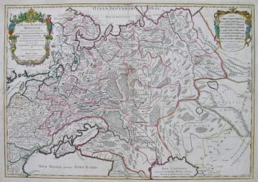
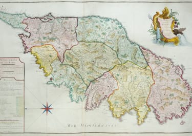
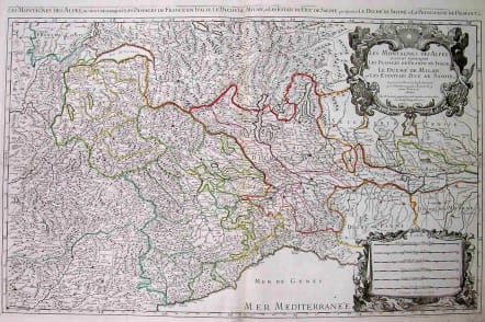
Full Title: Les Montagnes des Alpes ou sont remarques les Passages de France en Italie, le duche de Milan, et les Estats du duc de Syvoye &c. - Dresse sur les Memoires les plus Nouveaux par le Sr. Sanson, Geographe ordinaire du Roy. A Paris chez H. Iaillot joignant les grands Augustins aux deux Globes, Avec Privilege du Roypour 2o Ans. Superb very large Copper engraving, an uncolored fine example of a strong impression of this very large map. This issue is published and printed at Pierre Mortier in Amsterdam 1705. This large map, printed from two plates, was first published in the 'Atlas Noveau ...' by Alexis Hubert Jaillot & N. Sanson. In the right above corner ornated with a large decorative highly ornated allegoric figurative title-cartouche. Hubert Jaillot's map can be treated as a masterpiece of the French baroque cartography in the 17th century. It took Nicolaus Sanson and Hubert Jaillot a period of about fifteen years to complete this enormous work (c. 1681-96). The atlas was dedicated to Ludwig XIV.V.Large decorative cartouche.Small repair on back otherwise Mint condition. SOLD & ARCHIVEDcode : M1950
Cartographer : JAILLOT & COLLABORATORS
Date : 9000/ 1692/+ Amsterdam
Size : 54.5*87cms
availability : Sold
Price : Sold
JAILLOT and reissues
Alexis Hubert Jaillot (c.1632-1712). In 1664 he married Jeanne Berey, the daughter of Nicolas Berey, the map publisher, and following the death of his father-in-law and his brother-in-law (also Nicolas), the business passed to Jaillot and he was to gain access to much of the stock.
On the death of Nicolas Sanson, his firm passed to his sons Guillaume and Adrien. They took Alexis Hubert Jaillot into partnership in 1671, now well-established at 'Aux Deux Globes', and he was to become second only to Sanson himself among the early school of French cartographers.
A number of Sanson's maps had been prepared but never published and others were in need of revision, so Jaillot began the process of preparing new maps on larger plates. These were published in the "Atlas Nouveau", published from 1681 onwards, although individual maps date from 1672.
After the break-up of his partnership with the Sansons, Jaillot joined with the Amsterdam publisher Pierre Mortier, who engraved virtually identical copies of these large maps, re-issued from 1692 onwards. In a similar vein, Mortier also copied the maps from Jaillot's "Atlas Francois" to be re-issued by him in the "Atlas Royal".
These Jaillot atlases, both in the French and Dutch versions, mark the end of the dominance of the flamboyant Dutch school of cartography, which was superseded by the more scientifically based French school. Jaillot exemplified the scientific approach of the French school, which was to reach full maturity in the next century under Guillaume de l'Isle and his heirs, and Jean Baptist d'Anville, who established France as the centre of European cartography.