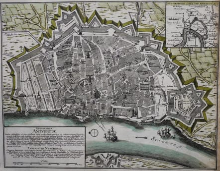
ICHNOGRAPHIA ANTVERPIAE
Sold
Rare and very attractive city plan of Antwerp.Interestingly major buildings in relief.. Good depiction of the famous citadel. Ships and compass rose.
Good original hand colour.
Right margin cropped tight with all map present.
Very good condition.
code : M2875
Cartographer : WEIGEL Christoph
Date : 1720 Nuremberg
Size : 33*41.5 cms
availability : Sold
Price : Sold
Christoph Weigel (c.1654-1725) and his relation Johann Weigel worked out of Nuremberg in the first half of the eighteenth century. Weigel is also known for a number of maps featuring in Faber’s “Atlas Scholasticus” (1718) and also the “Schul- Und Reisen Atlas”, produced in conjunction with JD Köhler.
Weigel was also involved with Köhler’s “Descriptio Orbis Antiqui” published c.1720. This volume contained in total forty four well engraved maps of the ancient world, many decorated with vignettes illustrating coins, medallions and mythological scenes.