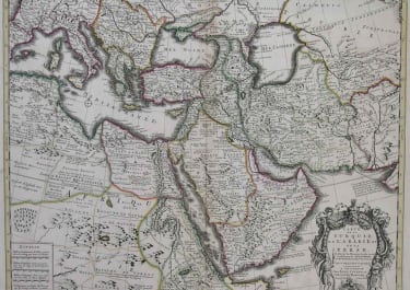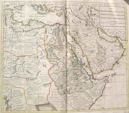
(MIDDLE EAST ARABIA,EGYPT) CARTE DE L'EGYPTE DE LA NUBIE DE L'ABISSINIE
£265
A superb example of De L'Isles highly detailed map of the region.The map extends west to include Sicily, the Southeastern Mediterreanean, Barbaria, Nigritie, and a Guinea on the West Coast of Africa. To the east, the map includes the Persian Gulf, Saudi Arabia, the Gulf of Aden and the Kingdom of Ajan and Dadel. De L'Isle's maps provided the first truly scientific mapping of the regions covered avoiding the flamboyant Dutch style of illustrations and adopting a highly detailed and decorative approach to the printed map. The result is a combination of spectacular detail and accuracy.Original outline colour.Mint condition.
code : M725
Cartographer : DE L'ISLE Family
Date : 1700/1720
Size : 49*58cms
availability : Available
Price : £265
Claude de l'Isle (1644-1720) was a geographer and historian working in Paris, but was overshadowed by his more famous son, Guillaume (1675-1726), who is probably the greatest figure in French cartography. Having learnt geography from his father, it is said that at the age of eight or nine he could draw maps to demonstrate ancient history. He studied mathematics and astronomy under J.D Cassini, where he received the grounding in scientific cartography, that is the hallmark of his work.
His first atlas was published in about 1700, in 1702 he was elected a member of the Academie Royale des Sciences, and in 1718 he became 'Premier Geographe du Roi'. His maps of the newly explored parts of the world reflect the most up-to-date information available and did not contain fanciful detail in the absence of solid information.
His work was important as marking a transition from the maps of the Dutch school, which were highly decorative and artistically-orientated, to a more scientific approach.
De L'Isle also played a prominent part in the recalculation of latitude and longitude, based on the most up-to-date celestial observations. His major contribution was in collating and incorporating this latitudinal and longitudinal information in his maps, setting a new standard of accuracy, quickly followed by many of his contemporaries. Guillaume De L'Isle's reputation was such that pirated versions appeared in many countries, most particularly by Chatelain and Covens and Mortier.
After his death in 1726 the business was continued by his nephew Philippe Buache, and subsequently by J. Dezauche.