ETATS DU GRAND-SEIGNEUR
Sold
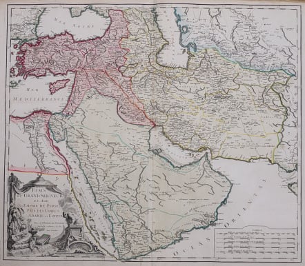
Very attractive and detailed copper-engraved map centered on the Arabian Peninsula, here called Arabie Heureuse.
This is a rare Vaugondy map from an Atlas that was given full original wash colour.
The map shows the Black and Caspian Seas, and extends to include modern Turkey, Persia, Syria, Israel, Saudi Arabia, Iraq, Iran (Persia), Uzbekistan, and much of Afghanistan. A Grand Desert is located between Mecca and Oman, today known as the Rub' al-Khali desert. The map is adorned with a decorative cartouche showing a Turkish sultan seated on pillows, smoking a long pipe, and five distance scales at lower right.
Very good condition for this unusual originally coloured map.
code : M3463
Cartographer : VAUGONDY ROBERT DE Family
Date : 1753 Paris
Size : 49*56 cms
availability : Sold
Price : Sold
The Robert de Vaugondy family responsible for map and globe publishing in Paris comprised Gilles Robert de Vaugondy (1688-1766) and Didier Robert de Vaugondy (1723-1786). The father (Gilles) and son (Didier) business flourished from 1731 to 1778.
Prominent at this time among French map-makers were the Robert de Vaugondy family, who made a substantial contribution to the eighteenth century world of cartography, through the breadth and success of their prolific output, which included atlases, maps, globes and book illustration.
While only a small part of their output, the "Atlas Universel" encapsulates the diligent and scientific approach adopted by the Roberts de Vaugondy, and proved to be the most successful French world atlas of the period. It appeared from c.1757 onwards.


