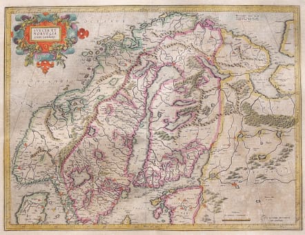

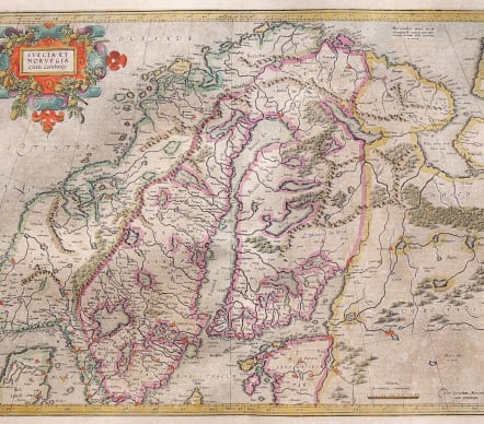
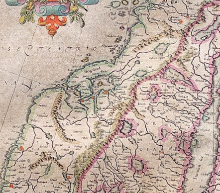
SCANDINAVIA SUECIA ET NORVEGIA CUM CONFINYS
Sold
Attractive early important map of Norway, Sweden and Finland. Shows rivers and mountains and names numerous cities. The map is based on Mercator's fifteen-sheet map of Europe dated 1554, which was revised in 1572. Mercator's map became the standard map of Scandinavia for most subsequent maps of the area. The map is adorned with a handsome strapwork cartouche and a stippled sea.
Printed after Jodocus Hondius' purchase of the Mercator business in 1604. The map itself is identical in all editions, but with text variants verso. This copy from the French issue 1613.
Good Full Original Colour. Wide margins.Light age pleasant age toning
Very Good condition.
Publication: Gerardi Mercatoris Atlas sive Cosmographicae
Ref: Ref: Ginsberg #34.0; Van der Krogt (Vol. I) #1210:1A.
William B. Ginsberg "Printed Maps of Scandinavia and the Arctic 1482 - 1601" Entry 34, Benedicte Gamborg Briså "Northward Bound at The Far Edge Of The World" Nordkappmuseet 2010, page 39 illustrated)
#1657
code : M3616
Cartographer : GERARD MERCATOR
Date : 1613 Amsterdam
Size : 37*48 cms
availability : Sold
Price : Sold
Gerard MERCATOR
Originally a student of philosophy Gerard Mercator (1512-1594). He became an expert in land surveying and cartography, as well as a skilled engraver.His first maps were published in 1537 (Palestine), and 1538 (a map of the world), although his main occupation at this time was globe-making. He later moved to Duisburg, in Germany, where he produced his outstanding wall maps of Europe and of Britain. In 1569 he published his masterpiece, the twenty-one-sheet map of the world, constructed on what is now known as Mercator's projection.
It was during this period, while teaching cosmography at Duisburg, that Mercator realised the pressing need for a modern collection of maps to supersede the Ptolemaic atlases. This project was gradually expanded to be a complete description of the Universe, both heaven and earth, with other volumes on the Creation, Genealogy and History and a Chronology. The description of the earth was to be in two parts, a modern geography and a Ptolemaic atlas, a massive and over-ambitious project. In fact, only the Chronology and the Ptolemaic Geographia were completed in his lifetime, and it was left to his son, Rumold, to complete and publish the world atlas in 1595. Entitled Atlas, sive Cosmographicae Meditationes de Fabrica Mundi, this was the first time the name "Atlas" was applied to a bound collection of maps, and, like Mercator's projection, has remained in everyday use to this day.
After Rumold's death in 1599, the plates for the atlas were published by Gerard Jr. Following his death in 1604, the printing stock was bought at auction by Jodocus Hondius, and re-issued well into the seventeenth century.
The Atlas Minor was reprinted,reengraved by many 16th century Dutch cartographers including Cloppenberg, Jansson etc.