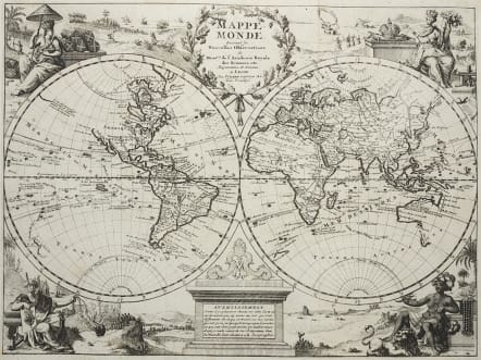
MAPPE-MONDE SUIVANT LES NOUVELLES OBSERVATIONS
Sold
Uncommon decorative world map in two hemispheres with vignettes symbolizing the four continents filling the corners. Title cartouche at top is balanced with an interesting representation of the world devoid of the oceans, as it would be seen from space. The map illustrates the routes of several sixteenth century explorers in the Pacific and Indian Oceans, including Magellan, Tasman, Chevalier de Chermont, Mendana and others. The western coastline of New Zealand is illustrated, along with parts of Australia and Tasmania. The entire northwest coast of North America is blank above the peninsular California. There is a remnant of the coastline that suggested a connection between North America and Asia on earlier maps; here with a notation concerning the discoveries of Vasco de Gamma. The eastern coast of Asia is truncated and a huge Terre d'Yeco forms the northern part of Japan.
Mint condition
code : M3371
Cartographer : Pieter Van Der AA
Date : 1720 Leiden
Size : 22.5*30 cms
availability : Sold
Price : Sold
Pieter Van Der Aa (1659-1733)
Van Der Aa was a prolific publisher, working in Leiden during the first three decades of the eighteenth century. Much of his output consisted of re-issues and re-engravings of map and view plates that he had acquired from earlier mapmakers. Little of his output was original, though that which is has a very distinct style, precisely and elegantly engraved, and is much sought-after today.
Perhaps his most remarkable publication was the elaborate Galerie Agreable Du Monde, issued in 1729, in 66 parts, bound into 27 volumes, which contained about 3,000 plates, apparently limited to 100 sets. Another of his extensive publications was the Cartes Des Itineraires Et Voyages Modernes, a collection of 28 volumes of travel accounts, illustrated with a series of small, but finely engraved maps, often with decorative pictorial title-pieces.
An interesting feature of Van Der Aa's method is that several of his atlases include maps printed within large, separately engraved, elaborately designed mock-frame borders, which were prepared with a blank centre so that individual maps could be over-printed on that area.
Despite the quantity and variety of Van Der Aa's publications they seem to have had only a limited circulation, and so are now scarce.