DALMATIAN COAST SERBIA ETC DALMATIAE,CROATIAE,SCLAVONIAE
Sold
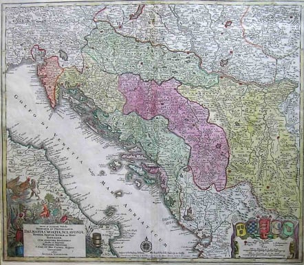
Full Title: Nova et accurata Tabula Regnorum et Provinciarum Dalmatiae, Croatiae, Sclavoniae, Bosniae, Serviae, Istriae, et Reip. Ragusanae, cum finitimis Regionibus Studio et Impensis Matthaei Seutteri, S. Caes. et reg. Cathol. Majest. Geographi edita Augustae Vindelicor.: Copper engraving, hand colored in outline and wash when published with later hand colour of cartouche.A large and very decorative map, which shows Dalmatia, Croatia and Slavonia. Many small place names, rivers, mountains, woods, islands, etc. The regions, which are engraved are Bosnia, Dalmatia, Albania, a part of Hungary, Transilvania, Croatia, the gulf of Venezia and a part of Italy. In the lower right corner we see a cartouche with five coat of arms from the regions of Dalmatia, Croatia, Slavonia, Bosnia and Serbia. At the bottom are two mileage scales. In the lower left corner is a large inset with the title. Bottom margin reinforced no loss to map which is complete.Very good condition.SOLDcode : M2042
Cartographer : SEUTTER Family
Date : 900/ 1720
Size : 50*58cms
availability : Sold
Price : Sold
Besides the Homanns, the other great German publishers of the eighteenth century were the Seutter family. Mattheus Seutter the elder (1678-1757) was apprenticed to Johann Baptist Homann in 1697 in Nuremberg, but left to settle in Augsburg where he established his own business publishing atlases, including the "Atlas Geographicus" (1725) and "Grosser Atlas" (circa 1735). Seutter's style was heavily influenced by Homann, with distinctive similarities appearing in his maps. He was joined in the business by his son, Albrecht (1722-1762), who continued the firm in partnership with Tobias Conrad Lotter (1717-1777) on his father's death.


