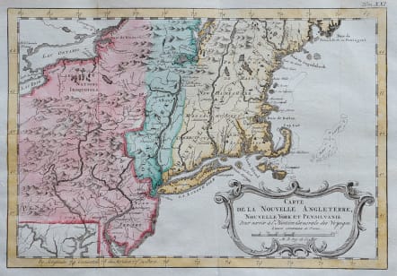
CARTE DE LA NOUVELLE ANGLETERRE NOUVELLE YORK ET PENSILVANIA
£225
Fine example of Bellin's map of New England and the Northeast Region.
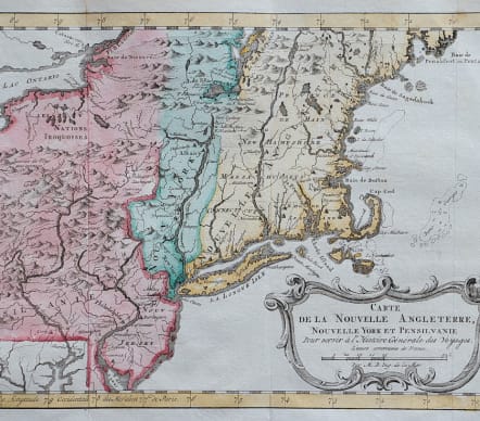
An excellent early map of the region bounded by New England, Lake Ontario and the northern Chesapeake River, centered on New York and Connecticut from Bellin's Histoire Generale des Voyages.
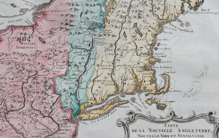
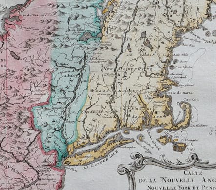
Shows towns, roads, mountains, rivers, islands, capes, ports and other nice details. A nice French and Indian War map of the Northern British Colonies.
Engraved by Jacob van der Schley (1715-79) after J. N. Bellin.
Bellin’s originals were published in Antoine Francois Prevost d’Exiles’ ‘Histoire Générale des Voyages’, a twenty-volume work published in Paris between 1746 and 1789. Guillaume Thomas Francois Raynal (1713-96) was a Jesuit author of many historical works including the ‘L’Histoire Philosophique et Politique des établissemens et du commerce des Européens dans les deux Indes’, first published in Amsterdam in 1770 in four volumes. It was perhaps his best-known work but was in fact banned in France, copies being publicly burned in 1779. Following the issue of an arrest warrant he fled the country only to return later and become elected States-General, such were the vagaries of French politics of the time.
Excellent hand colour
Very good condition
This map is from the ‘Atlas Portatif pour server a l’Intelligence de ‘L’Histoire Philosophique et Politique’, designed to accompany the larger work. It was first published in 1773 from which this example comes.
code : M5589
Cartographer : Jacques-Nicolas BELLIN
Date : 1773 Paris
Size : 21*30 cms
availability : Available
Price : £225
Jacques-Nicolas Bellin (1703-1772) was one of the most important and prolific French cartographers of the mid-eighteenth century, in the service of the French Hydrographical Office. He was appointed the first Ingenieur Hydrographe de la Marine, and also Official Hydrographer to the French King.
Bellin was responsible for an enormous output of charts and maps. In a large folio format, he issued a volume of sea-charts of France, the Neptune Francois, and several sea-atlases of the World, including the Atlas Maritime and the Hydrographie Francaise. These large charts were amongst the best of the period and continued being reissued throughout the second half of the eighteenth century.
In smaller format, he issued the Petit Atlas Maritime (1764),which contained 580 detailed charts, as well as maps to illustrate l'Abbe Prevost's Histoire Generale des Voyages (1746-1757). Bellin also produced a substantial number of important separately issued maps, particularly reflecting continuing discoveries and political events in the Americas.


