SOUTH AFRICA CAPE TOWN THE CAPE
Sold
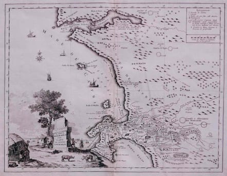
Full title Carta Geografica del Capo di Buona Speranza
A detailed map of the Cape of Good Hope from 'Atlante Novissimo che Contiene Tutte le Parti del Mondo'. Decorative cartouche shows an elephant and two species of rhinosaurus.
One of the most interesting features of this map is that the plantations in the area of todays Stellenbosch are marked with the owners names Cornelio De Boer, Simon de Groot etc.
The emphasis of the map is on the best places to make landfall and on settlement. Aside from already established tracts of land, the map identifies arable land, meadows, marshes, valleys and other topographical features such as Table Mountain, the Helderberg, ‘Monti di Perle' (Paarl Rock) and ‘Monti Cavalli' (the Paardeberg). Interestingly, the legend explains the ring formation and function of the ‘Hottentot' (Khoikhoi) ‘coralli' or kraal. The map is decorated with a title vignette depicting Khoikhoi building a traditional round dwelling, an elephant, rhinoceroses and ships.
Uncoloured as issued.
Very good condition.
Norwich 218
code : M2671
Cartographer : Albrizzi Giovani
Date : 1741 Venice
Size : 35*45 cms
availability : Sold
Price : Sold
Although Venice had been the centre of the European map-trade in the 1550s, its importance had been subsequently eclipsed by Antwerp and then Amsterdam in the late sixteenth and seventeenth centuries. So it was from Amsterdam that Giovanni Battista (Giovambattista) Albrizzi, the Italian, took inspiration for his best-known atlas - the Nieuwe En Beknopte Handatlas ... by Isaak Tirion was translated into Italian and published in Venice by Albrizzi. Albrizzi was also responsible for publishing an edition of Guillaume De L'Isle's atlas as Atlante Novissimo.


