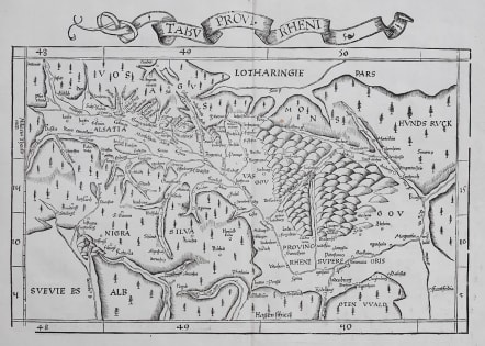
TABU PROVI RHENI FRIES
Sold
THE RHINELAND AND ALSACE
Very attractive, early woodcut map of southwestern Germany depicting the Black Forest region and Rhine River valley along the German borders with France and Switzerland.
Cities marked include Strasbourg, Heidelburg and Frankfurt.
One of the earliest available maps of the region.
Second edition (of four) of this map based on Waldseemüller's modern map of Rheinland-Pfalz.
Recto is a map of Lorraine ( 33.5 x 23 cm. ) and . text contained within elaborate Renaissance woodcut panels which may have been designed by Albrecht Dürer, the known contributor to diagrams elsewhere in the atlas.
Mint condition
code : M5030
Cartographer : FRIES Lorenz
Date : 1525
Size : 30*43 cms printed area inc title
availability : Sold
Price : Sold
Laurent Fries (*1485 - †1532)
Laurent Fries was a French physician and mathematician born around 1485 in Mulhouse. He settled finally in Strassburg where he meat Peter Apian and the publisher Johannes Grüninger which made him interested in the Ptolemy Atlas of 1513 and 1520. Fries made new woodcut maps in reduced size. His Ptolemy Atlas was published first in 1522, reissued in 1525, 1535 and 1541. He died in 1532.