
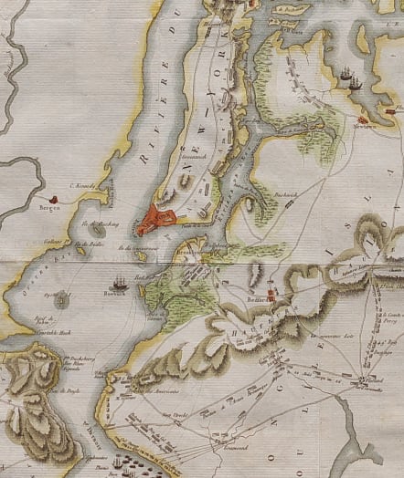
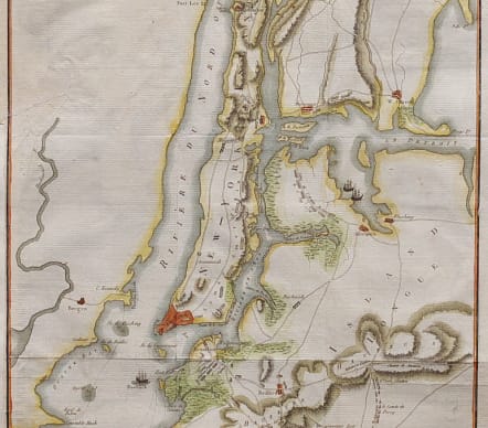

ILE DE NEW YORK PARTIE DE LONG-ISLAND OU DE L'ILE LONGUE
Sold
Full Title: Île de New-York, Partie de Long-Island ou de l’Île Longue, et Positions des Armées Américaine et Britannique, Après le Combat livré sur les Hauteurs, le 27 Aout 1776
Attractive and detailed French Revolutionary War map of Manhattan and parts of New Jersey, Brooklyn, the Bronx and Queens.
The map illustrated a biography of George Washington and records troop movements and locations between August 22 and 27, 1776, now known as the Battle of Brooklyn. Rivers, elevated areas (“hauteurs”), marshes and major roads are indicated, as are positions of troops and names of their commanders. Ships are illustrated and labeled in the harbor.
Named features include Fort Independence, Fort Lee, Hudson River, York Bay, Oyster Bay, Hell Gate, Governor's Island, the East River, Staten Island, Bergen, Flushing, Brooklyn, East Chester and West Chester. Numerous roads and the position of several named ships are also noted including the Roebuck, the Rose, the Greyhound, and the Thunder.
Closed tear professionally repaired where attached in book.
Excellent hand colour
Very good condition.
Publication : Vie De George Washington. Collection de Planches
code : M4742
Cartographer : P. BAUCHE
Date : 1807 Paris
Size : 46*28 cms
availability : Sold
Price : Sold