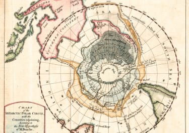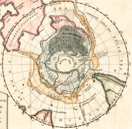
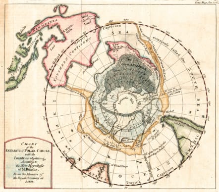
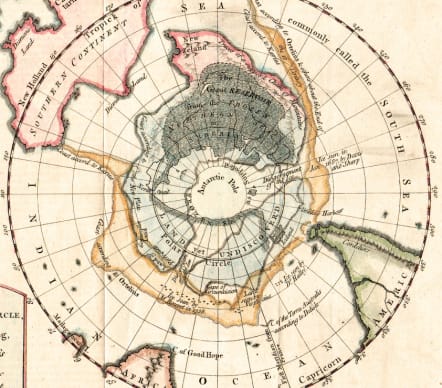
CHART OF THE ANTARCTIC POLAR CIRCLE
£275
Antarctica)Chart of the Antarctic Polar Circle, with the Countries adjoining, According to the New Hypothesis of M. Buache. From the Memoirs of the Royal Academy at Paris.
Fascinating v early & peculartive map of Antarctica.
The Antarctic appeared on very early maps as a large island. This disappeared for lack of evidence and for some time nothing is shown in the region. By 1763 navigators had reported the presence of something and there was again debate on what might be there. Bauche proposed a unique combination of lands and ice and this map was issued to illustrate it. On it he notes numerous discoveries, traces the known land masses to the north, and propounds his theory. Here New Zealand is part of the extended reaches of a south polar land mass.
Good hand colour
Very good condition
Ref: R Jolly GENT-166.
https://www.davidrumsey.com/luna/servlet/detail/RUMSEY~8~1~352905~90120145:Chart-of-the-Antarctic-Polar-Circle
**
Pub Note:
Hand colored map of the southern Polar Region (Antarctic) , 20x23, based upon the map of Philippe Bauche, published in Paris. This map in black and white, drawn by the scientific geographer M. Buache was published in 1763 by the Gentleman's Magazine, a famous 18th century English journal, as part of an article entitled Geographical and Physical Observations, A new theory of the earth, including a Theory of the Antarctic Regions, and the frozen Sea which they are supposed to contain, according to the Hypothesis of the M. Buache. This chart centers on the South Pole and extends northwards as far as the Tropic of Capricorn. Though predating the discovery of Antarctica by more than half a century, Buache's map details a fanciful Antarctic Pole sandwiched between the tip of Cape Horn, the Cape of Good Hope, and southern Australia, which stretches northwards off the map as far as New Guinea to which the mainland of Australia erroneously attached and Indonesia in the upper left. The map also showing 17th & 18th century land and ice sightings in the southern seas, and name drops De L'Isle, Drake, Halley, and even Ortelius. Heading inward towards the Pole, the map shows a circle labeled ‘Land Yet Undiscovered,' and another within that, labeled ‘Frozen Sea as Supposed.' None of which stops it from depicting the best guesses as to what might exist there. Most interestingly, New Zealand is only the northernmost tip of a great southern continent. Buache was an academic geographer who researched his material thoroughly, relying on the most up-to-date information from voyages of discovery.
code : M5460
Cartographer : P. BAUCHE
Date : 1763 London
Size : 19.5*23 cms sheet 21*27 cms
availability : Available
Price : £275
Inherited De L'ISles plates and reissued his famous Atlas.