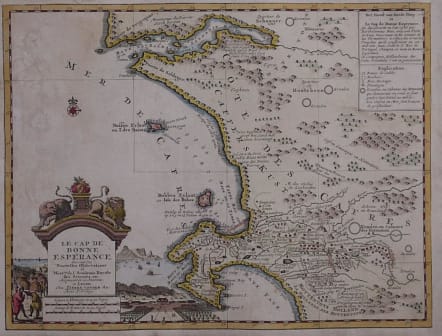
LE CAP DE BONNE ESPERANCE
Sold
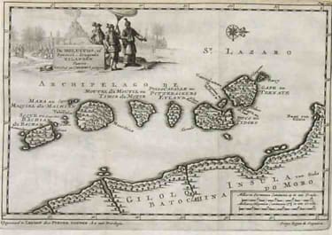
A fine detailed copperplate map with charming pictorial cartouche with background of Table Bay,Companys Gardens etc.The map itself covers the area from Saldanha Bay to False Bay and depiocts the terrain accurately, mountains rivers woodlands freshwater,which would have been very important in 1729.It also shows the location of Fauna,elephants,rhonos,Lions.
Excellent hand colour.
Slight bemish to left of map. Professionally laid down.
Otherwise a very good example of this rare map.
.
Reference: Tooley,Map Collectors Circle No 6 Early Maps of Cape Of Good Hope. Ref 10 Page 9
code : M2881
Cartographer : Pieter Van Der AA
Date : 1729 Leiden
Size : 22*30cms
availability : Sold
Price : Sold
Pieter Van Der Aa (1659-1733)
Van Der Aa was a prolific publisher, working in Leiden during the first three decades of the eighteenth century. Much of his output consisted of re-issues and re-engravings of map and view plates that he had acquired from earlier mapmakers. Little of his output was original, though that which is has a very distinct style, precisely and elegantly engraved, and is much sought-after today.
Perhaps his most remarkable publication was the elaborate Galerie Agreable Du Monde, issued in 1729, in 66 parts, bound into 27 volumes, which contained about 3,000 plates, apparently limited to 100 sets. Another of his extensive publications was the Cartes Des Itineraires Et Voyages Modernes, a collection of 28 volumes of travel accounts, illustrated with a series of small, but finely engraved maps, often with decorative pictorial title-pieces.
An interesting feature of Van Der Aa's method is that several of his atlases include maps printed within large, separately engraved, elaborately designed mock-frame borders, which were prepared with a blank centre so that individual maps could be over-printed on that area.
Despite the quantity and variety of Van Der Aa's publications they seem to have had only a limited circulation, and so are now scarce.