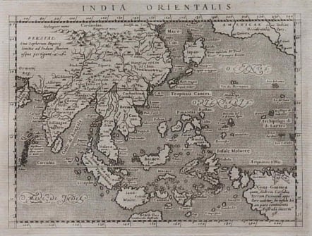
INDIA ORIENTALIS
Sold
Beautifully engraved small map of the island groups based on Ortelius' classic map of the region, sans the decorative details. Sumatra is named as Taprobana, and Japan is shown in its kite-shaped configuration. The western coast of North America appears in the upper right corner with the place names of Quivira, Cicuic and Tiguex. A massive New Guinea appears in the lower left, while a little protrusion of the southern continent is named as Beach pars, from the reports of Marco Polo. The seas are stipple engraved with dramatic calligraphic lettering. Engraved by Girolamo Porro.
Mint condition
Ref: Parry, The Cartography of the East Indian Islands, pp 79-80.
code : M3161
Cartographer : MAGINI Giovanni
Date : 1598
Size : 13*17 cms
availability : Sold
Price : Sold
Giovanni Antonio Magini (1555-1617) was born in Padua, Italy, and studied medicine, mathematics, astronomy and philosophy at the University of Bologna where he was later to become a professor of astronomy. He corresponded with many of the renowned figures of the age including Ortelius, Tycho Brahe, Galileo and Johanes Kepler. He authored various works on astronomy and also produced the first printed atlas of Italy, which was published posthumously by his son Fabio. Other works included the "Geographiae Universiae" (1597) and "Moderne Tavole Di Geografia" amongst others.