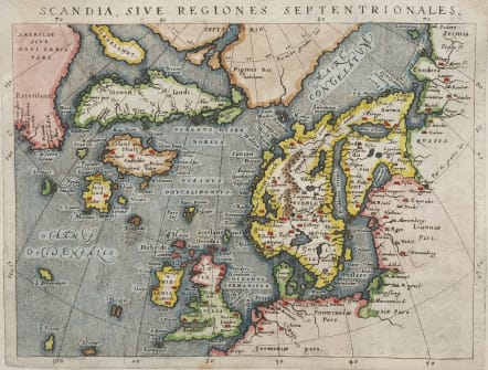
SCANDIA SIVE REGIONES SEPTENTRIONALE
£450
Uncommon map based on Ortelius' Septentrionalum of 1570, which in turn was based on the mapping of Nicholas Zeno in 1558. The map shows two Greenlands, one just above the other, as well as the imaginary islands of Frisland and St. Brendain, along with many other small, phantom islands in the North Sea. The North Pole carries a note of Pigmei hic habitant, indicating that pygmies live there. The island of Drogeo shown off the coast of Estotilant is thought to represent Newfoundland. Beautifully engraved with Latin text on verso, from an edition of Geographiae Universae printed in Cologne by Petrus Keschedt.
Excellent hand colour
Very good condition
References: Burden, #98; Ginsberg (Scandinavia), #24.
From: Geographicae Universae tum veteris novae . . . Auctore Io. Ant. Magino. Cologne, P. Keschedt, 1597. - Pirate edition after Magini's original work of 1596.
code : M4795
Cartographer : MAGINI Giovanni
Date : 1597
Size : 13.5* 18 cms
availability : Available
Price : £450
Giovanni Antonio Magini (1555-1617) was born in Padua, Italy, and studied medicine, mathematics, astronomy and philosophy at the University of Bologna where he was later to become a professor of astronomy. He corresponded with many of the renowned figures of the age including Ortelius, Tycho Brahe, Galileo and Johanes Kepler. He authored various works on astronomy and also produced the first printed atlas of Italy, which was published posthumously by his son Fabio. Other works included the "Geographiae Universiae" (1597) and "Moderne Tavole Di Geografia" amongst others.


