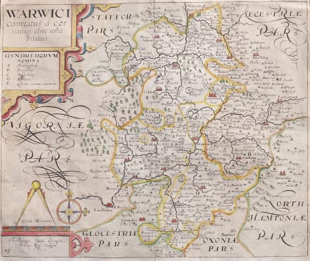
WARWICI COMITATUS
Sold
Attractive detailed and early map of Warwickshire.
Geography from Christopher Saxton and engraved by William Kip. From the third edition of Camden's Britannia to contain maps.
Decorative with compass rose cartouches etc
From Tameworth to Shipton with Warwick, Rugby, Bermicham etc marked.
Good Hand colour
Margins a little tight
Very good condition
code : M4572
Cartographer : KIP William
Date : 1637 London
Size : 29.5*35 cms
availability : Sold
Price : Sold
CAMDEN'S BRITANNIA: William KIP & William HOLE
William Camden (1551-1623) was an English historian and antiquary who devoted himself to the study of the antiquities of Britain, travelling round the country visiting sites. The results of his work were brought together in the "Britannia", first published in 1586 then much reissued and augmented over the following two centuries. However, one of the few criticisms levelled at the 186 first edition of this work was the absence of maps.
This failing was remedied in the sixth edition of 1607 for which maps were commissioned from William Kip and William Hole. Drawing on the surveys of Christopher Saxton, John Norden and the Anonymous/William Smith series, they produced a series of 57 maps.