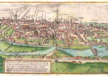
NAPLES HAEC EST NOBILIS & FLORENS ILLA NEAPOLIS CAMPANIAE
£750
Stunning view of Naples by Braun & Hogenberg which was included in the great town book Civitates Orbis Terrarum. Braun wrote the text and Ortelius - who travelled with the artist Joris Hoefnagel - supplied much of the material, which was then engraved by Novellus and Hogenburg.
The Historiv centre, Spanish quarter the forsts etc are as they are today
Great birds eye view
Excellenty hand colour
Excellent condition.
The text in the cartouche: This is the notable and flourishing city of Naples in Campania, formerly called Parthenope, after Parthenope the siren, who was buried in this place. As legend relates, the sirens cast themselves into the sea in fury after they had been unable to seduce Odysseus and his companions with their song. Naples, today the residence of illustrious families and most learned men, is distinguished for the wonderful mildness of its air and its delightful location, the magnificence of its churches, private houses and palaces, beautiful tombs of kings, queens and high-ranking persons, and a university with all the faculties.
BRAUN's text in Civitatis : "The fertile region around Naples [...] was the reason that the Romans liked to go to Naples after their work to rest and relax and to seek entertainment. This is where, amongst others, the most excellent poet Virgil lived, who wrote his Georgica book on agriculture here, so Servius says. Livy, Horace, Claudianus, Francesco Petrarch, Lorenzo Valla, Flavio Biondo and many others also lived here. [...] The streets are clean and straight. The strongest fortress in Naples is the Castel Nuovo, which may be rightly considered the safest castle in all Europe."
code : M5388
Cartographer : BRAUN & HOGENBERG
Date : 1575 Cologne
Size : 33.5*48 cms Sheet 40.5*53.5 cms
availability : Available
Price : £750
Georg Braun (1541-1622) and Frans Hogenberg (1535-1590) were co-publishers of the monumental Civitates Orbis Terrarum, “the earliest systematic city atlas” (Koeman), published from 1572 onwards. Designed as a companion to Ortelius’ world atlas the Theatrum, this enormous work, which was expanded to six volumes by 1617 incorporating over 500 plans and views, must be viewed as one of the most ambitious book producing ventures of all time, and certainly, with Ortelius’ Theatrum and Blaeu’s Atlas Maior among the greatest achievements in the history of cartography.
Braun compiled the accompanying text, printed on the reverse of the engraved sheets, while the plans were engraved by Hogenberg, who had also prepared some of the maps for Ortelius’ Theatrum. Hogenberg used generally up-to-date and accurate maps, surveys and reports from local sources to compile this collection of plans and bird’s-eye views of all the major towns of Europe, some African, Middle Eastern and Indian towns, and the New World cities of Mexico and Cusco. One of the major contributors was Georg (or Joris) Hoefnagel, who supplied some 63 manuscript drawings, the vast majority from personal observation.