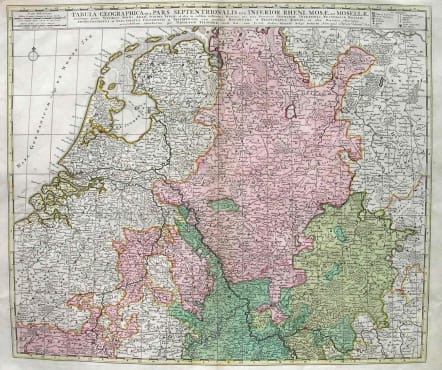
RHINE TABULA GEOGRAPHICA QUA PARS SEPTENTRIONALIS SIVE INFERIOR RHENI
£175
Interesting map by Visscher and Schenk of the Rhine from Mainz to the Sea.Detailed.Good full original colour.Very good condition.code : M1945
Cartographer : Nicolaas VISSCHER
Date : 1690c Amsterdam
Size : 48*56cms
availability : Available
Price : £175
Among the many great Dutch map publishers active in the seventeenth century were the Visscher family; the firm was begun by Claes Jansz Visscher (1587-1652), and subsequently included his son Nicolaas (1618-1679), grandson Nicolaas II (1649-1702) and then his grandson’s widow, Elizabeth, until her death in 1726.
Although mainly art dealers, the Visschers were prolific publishers, producing individual maps and also atlases made up to their customers’ specifications. Indeed, they are commonly regarded as second only to the Blaeus among Dutch map-makers for the high quality of engraving and decoration and the geographical accuracy of their many maps. Particularly outstanding - not only as maps but as works of art - are their world maps.