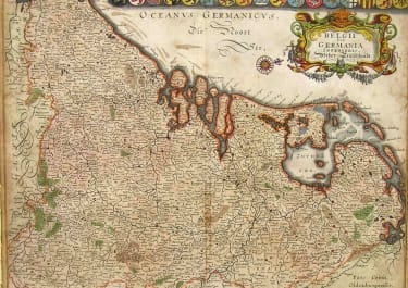
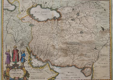
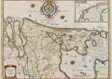
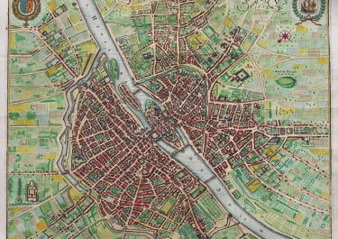
HOLLANDIA COMITATUS HOLLAND AMSTERDAM
£225
Superb map of Holland.
As all Merian maps beautifully engraved. This map is basically a slightly reduced version of the Blaeu map. Covers area from Rotterdam to Texel and includes Amsterdam and Utrecht.
Very decorative with Cartouche large emblem of rampant lion, 3 compass rose and numerous ships.
Excellent hand colour
Very good condition
code : M5194
Cartographer : MERIAN Matthaus MERIAN
Date : 1650 Frankfurt
Size : 26*35cms sheet 31*37 cms
availability : Available
Price : £225
Matthäus Merian der Ältere (or "Matthew", "the Elder", or "Sr."; 22 September 1593 - 19 June 1650) was a Swiss-born engraver who worked in Frankfurt for most of his career, where he also ran a publishing house.
Born in Basel, Merian learned the art of copperplate engraving in Zürich. He next worked and studied in Strasbourg, Nancy, and Paris, before returning to Basel in 1615. The following year he moved to Frankfurt, Germany where he worked for the publisher Johann Theodor de Bry, who was the son of renowned engraver and traveler Theodor de Bry.
In 1623 Merian took over the publishing house of his father-in-law after de Bry's death. In 1626 he became a citizen of Frankfurt and could henceforth work as an independent publisher. He spent most of his working life in Frankfurt.
He produced the 21-volume set was collectively known as the Topographia Germaniae. It includes numerous town plans and views, as well as maps of most countries and a World Map-it was such a popular work that it was re-issued in many editions. He also took over and completed the later parts and editions of the Grand Voyages and Petits Voyages, originally started by de Bry in 1590.
After his death, his sons Matthäus Jr. and Caspar took over the publishing house. They continued publishing the Topographia Germaniae and the Theatrum Europaeum under the name Merian Erben (i.e. Merian Heirs).