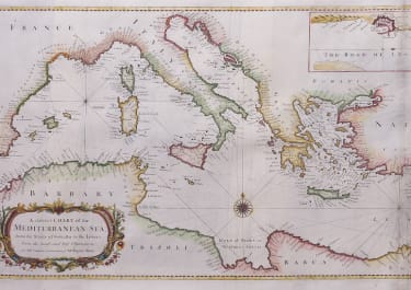
A CORRECT CHART OF THE MEDITERRANEAN SEA
Sold
Superb large sea chart of the Mediterranean.Very finely engraved with Rumb lines,anchorages and a compass rose.Decorative cartouche,inset of Livorno.Folds as issued.Very good condition/mint.code : M1461
Cartographer : Seale, Richard
Date : 1742 London
Size : 36*72cms
availability : Sold
Price : Sold
Richard William Seale (d.1785, fl.1732-1772) was a well-known engraver and draughtsman working in London. His work is often encountered in the maps from Tindal’s continuation of "Rapin's History Of England" (1744-1777). The atlas primarily contains maps depicting the military actions fought by the English during the campaigns of the War of the Spanish Succession, notably in the Low Countries, but also in Spain, and was also supplemented by a series of contemporary maps, of the countries of the British Isles, and parts of the wider world. Seale also contributed to a large number of other books, magazines and atlases of the period – the “London Magazine” and the “Universal Magazine”.