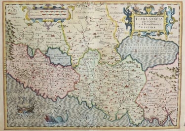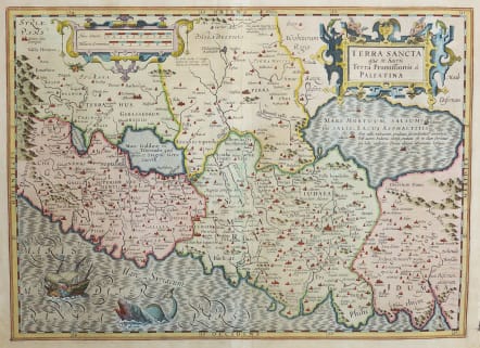
TERRA SANCTA QUE IN SACRIS TERRA PROMISSIONIS OL PALESTINA
£375
Attractive map of the Holy Land oriented with east at the top. The land is shown divided into theTwelve Tribes and is centered on Samaria. This map is based on Ortelius' map of the region from 1570, which in turn was based on Peter Laicksteen's wall map describing his 1566 visit to the Holy Land. The Dead Sea has four cities shown burning within it: Sodoma, Gomorra, Adama and Seboim. The Mediterranean Sea is enlivened with a depiction of Jonah being cast out of the ship and into the waiting jaws of the whale. The map is adorned with two strapwork cartouches. Latin text on verso.
Mercator Hondius
Good original colour
Very good condition
code : M4027
Cartographer : GERARD MERCATOR
Date : 1620 Amsterdam
Size : 35.5*49.5 cms
availability : Available
Price : £375
Gerard MERCATOR
Originally a student of philosophy Gerard Mercator (1512-1594). He became an expert in land surveying and cartography, as well as a skilled engraver.His first maps were published in 1537 (Palestine), and 1538 (a map of the world), although his main occupation at this time was globe-making. He later moved to Duisburg, in Germany, where he produced his outstanding wall maps of Europe and of Britain. In 1569 he published his masterpiece, the twenty-one-sheet map of the world, constructed on what is now known as Mercator's projection.
It was during this period, while teaching cosmography at Duisburg, that Mercator realised the pressing need for a modern collection of maps to supersede the Ptolemaic atlases. This project was gradually expanded to be a complete description of the Universe, both heaven and earth, with other volumes on the Creation, Genealogy and History and a Chronology. The description of the earth was to be in two parts, a modern geography and a Ptolemaic atlas, a massive and over-ambitious project. In fact, only the Chronology and the Ptolemaic Geographia were completed in his lifetime, and it was left to his son, Rumold, to complete and publish the world atlas in 1595. Entitled Atlas, sive Cosmographicae Meditationes de Fabrica Mundi, this was the first time the name "Atlas" was applied to a bound collection of maps, and, like Mercator's projection, has remained in everyday use to this day.
After Rumold's death in 1599, the plates for the atlas were published by Gerard Jr. Following his death in 1604, the printing stock was bought at auction by Jodocus Hondius, and re-issued well into the seventeenth century.
The Atlas Minor was reprinted,reengraved by many 16th century Dutch cartographers including Cloppenberg, Jansson etc.