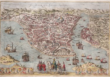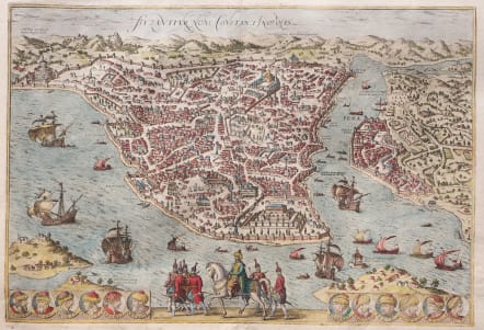
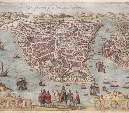
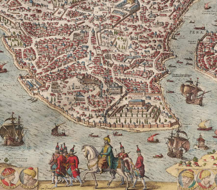
BYZANTIUM NUNC CONSTANTINOPOLIS
£
SOLD
Attractive and fine early bird’s-eye-view of Istanbul, from Braun and Hogenberg's monumental town book.
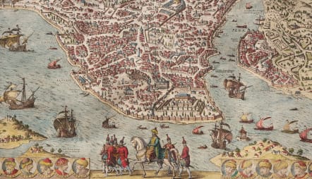
The Braun and Hogenberg view is one of the finest and most sought-after depictions of Istanbul. Viewed across the Bosphorus from the village of Scutari (Üsküdar), the city is shown with an emphasis on its fortifications and famous buildings. Pera-Galata is across the Golden Horn, to the right of the view.
Many of the great buildings of the city are evident, including the Topkapi Palace. The Hagia Sophia is near to the palace, while the many-domed Fatih Mosque complex sprawls toward the western city walls. Just outside the city walls, at left, is the rising Tekfur Palace. In Pera are the new shipyards.
Along the view’s lower edge, Suleiman the Magnificent rides at the center. The Ottomans sultans have their portraits on either side of him, from Osman Bey to Murad III.
This is the third state of the view, with the second state addition of the portrait of Sultan Murad III in the roundel at the right (this roundel is blank in state one) and privilege added ("Cum Privilegio").
Condition Verso shows signs of previous framing with slight discolouration from backing boards, a few small chips on edges otherwise good condition.
Very good hand colour
Good example of this sought after birds eye view.
References: Van der Krogt 4 - 1912 state 1; Fauser - 6824; Taschen (Br. Hog.) - p.119.
Was 1545
SOLD
code : M5465
Cartographer : BRAUN & HOGENBERG
Date : 1585
Size : 33*48 cms sheet 42*53 cms
availability : Available
Price : £
Georg Braun (1541-1622) and Frans Hogenberg (1535-1590) were co-publishers of the monumental Civitates Orbis Terrarum, “the earliest systematic city atlas” (Koeman), published from 1572 onwards. Designed as a companion to Ortelius’ world atlas the Theatrum, this enormous work, which was expanded to six volumes by 1617 incorporating over 500 plans and views, must be viewed as one of the most ambitious book producing ventures of all time, and certainly, with Ortelius’ Theatrum and Blaeu’s Atlas Maior among the greatest achievements in the history of cartography.
Braun compiled the accompanying text, printed on the reverse of the engraved sheets, while the plans were engraved by Hogenberg, who had also prepared some of the maps for Ortelius’ Theatrum. Hogenberg used generally up-to-date and accurate maps, surveys and reports from local sources to compile this collection of plans and bird’s-eye views of all the major towns of Europe, some African, Middle Eastern and Indian towns, and the New World cities of Mexico and Cusco. One of the major contributors was Georg (or Joris) Hoefnagel, who supplied some 63 manuscript drawings, the vast majority from personal observation.