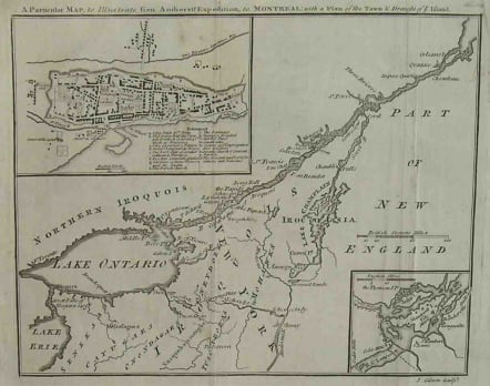
MONTREAL A PARTICULAR MAP TO ILLUSTRATE GEN AMHERSTS EXPEDITION TO MONTREAL
Sold
This map illustrates the expedition led by General Lord Jeffrey Amherst against the French at Montreal in 1760, which led to the surrender of the city in September of that year. It shows the region along and south of the St. Lawrence River extending from Quebec to the Thousand Islands, and then around Lake Ontario and to the Niagara River. Forts, Indian tribes, rivers, portages, and other such information is clearly presented. Also included are insets of Montreal Island and of the city itself, indicating its major streets, buildings, and the surrounding fortifications.
Very good condition.
This scarce map focuses on the decisive action which ended the French and Indian War- the final struggle between the French government, and its colonies in America, and the English government and its colonies in America for imperialistic control of the North American continent. In September, 1760 General Amherst, commander of British troops in America, led an expedition down the St.Lawrence River and captured Montreal completing the conquest of Canada. The insets provide a view of the region immediately around Montreal, and a very detailed city plan. It was published only one month after the battle.
code : M2125
Cartographer : John GIBSON
Date : 1760London
Size : 18.5*23.5cms
availability : Sold
Price : Sold
John Gibson, contemporary to Bellin and Bonne, was an important British cartographer of the late 18th century. He produced thousands of maps and was noted as a skilled engraver and sculptor. Gibson's most important work is the pocket sized 1758 Atlas Minimus. Gibson unfortunately was not as astute in his personal life as he was with the engravers pen and spent much of his life in and out of debtor's prison.

