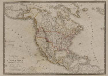
CARTE GENERALE DES ETATS UNIS DE L'AMERIQUE SEPTENTRIONALE
Sold
Attractive detailed early example of the United States mapped from coast to coast.
Incredible detail on American Indian tribal names.
The map is interesting west of the Mississippi, where it shows a double wide Arkansa Territory, Oregon Territory extending from the Mississippi to the Paicfic, early regional reference to Texas, two Salt Lakes w/two rivers flowing to the Pacific, fabulous detail in the Pacific Northwest relying upon Lewis & Clark.
The map is one of the most detailed renderings of the drainage systems of the Rockies and Upper Mississippi prior to Nicollet. Several early forts are shown in Texas. The Missions and early mythical rivers shown in California.
Piano key border , swash lettering title. Wide margins.
Excellent wash colour.
Mint condition
code : M4814
Cartographer : BRUE Adrien
Date : 1820 Paris
Size : 37.5*51 cms
availability : Sold
Price : Sold
Adrien Hubert Brue (1786-1832) was an important French geographer and publisher at the ‘rue des Macons-Sorbonne’. He held the titles of ‘Geographe du roy’ and also ‘Geographe de son Altesse royale Monsieur le comte d’Artois’.