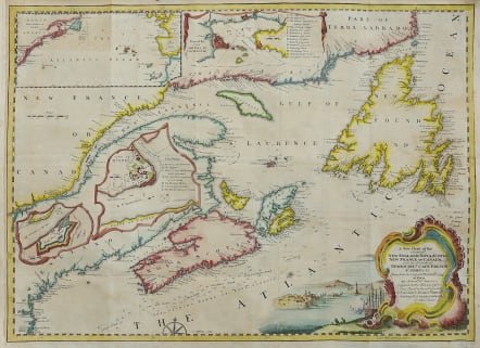


A NEW CHART OF THE COAST OF NEW ENGLAND, NOVA SCOTIA NEW FRANCE OR CANADA
£325
A New Chart of New England, Nova Scotia, New France or Canada with the Islands of Newfoundland. Cape Breton St. John &c. Done from the Original Publish'd in 1744 at Pars, By Monsr. N. Bellin, Engineer to the Marine Office
Scarce colonial map by Thomas Jefferys after Nicolas Bellin dedicated to the British Merchants trading in North America.
Attractive regional map of the Northeast and contiguous parts of Canada, from the January 1746 issue of Gentleman's Magazine.
The map shows in detail the eastern coast of Canada and New England, with the great fishing banks and the depths soundings.
The map includes insets of Quebec City, Fort Dauphine, the Atlantic Ocean, and a Plan of City and Port of Louisbourg. The Louisbourg and Quebec insets each contain a key to greater detail.
Excellent hand colour
Sought after essential Canada collectors map in very good condition
code : M4842
Cartographer : Jefferys T
Date : 1746 London
Size : 34.5*47 cms
availability : Available
Price : £325