WEST CANADA
£125
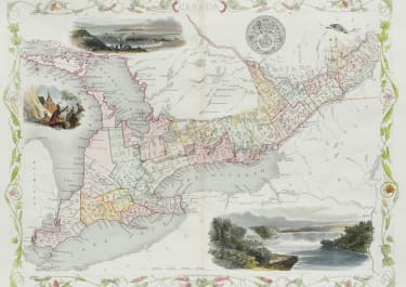
This is John Tallis’ extremely attractive c. 1850 map of West Canada or what is now Ontario. Includes Lake Erie, Lake Ontario, and part of Lake Huron with Georgian Bay. Features five stunning vignettes which include Several American Indians sitting around a tree with a teepee in the background, an otter, and in the lower right quadrant, Niagara Falls. The whole is surrounded by a decorative vine motif border. The vignettes for this map were drawn by H. Warren and engraved by Robert Wallis. The map itself is the work of John Rapkin. Issued for inclusion in John Tallis’ 1851 Illustrated Atlas
Original outline colour. Vignettes with later hand colour.
Very good condition
code : M5162
Cartographer : Tallis John
Date : 1845 London
Size : 36.5 *26.5cms
availability : Available
Price : £125
TALLIS, John
active 1838-1851
John Tallis founder of Tallis and Co., London map publishers who traded under various names: L. Tallis, Tallis & co, John Tallis, John Tallis & co. (London & New York) between 1838 and 1851. After 1850-51, their maps were published by the London Printing and Publishing Co., London and New York.
The Illustrated Atlas of the World, published in 1849 with the maps and decorative vignette's engraved and drawn by J. Rapkin, was one of the last atlases to be truly decorated and is therefore highly prized.