GRONLAND
Sold
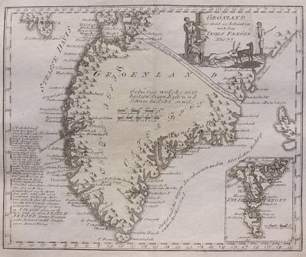
This uncommon and interesting Austrian map is one of the few 18th century maps devoted to Greenland. Due to a general lack of knowledge of the region, detail in confined along the coastline, which is portrayed as mountainous with numerous fiords and islands. There are several 17th century errors including two spurious sea passages. A large inset shows the Faeroe Islands. A panel of text describes the country including a notation that it is not known if Greenland is an island or a peninsula off North America.
Original wash colour
Very good condition.
code : M3387
Cartographer : REILLY VON Franz Johann Joseph
Date : 1791 Vienna
Size : 23*28 cms
availability : Sold
Price : Sold
Austrian born Franz Johann Joseph von Reilly (1766-1820) produced over 830 maps for his great atlas project, "Schauplatz der funf Theile der Welt" between the years 1789 and 1806. Of these 830 maps published over this time span of seventeen years, he 'showcased' but one part of the world, Europe. Maps of the other four continents remained unpublished. The maps of the "Schauplatz ..."were drawn to a uniform criteria.
Reilly's "Grosser deutscher Atlas" was also notable as the first completely 'Austrian' atlas. This large world atlas, containing relatively few maps, was issued between 1794 and the end of 1796. Reilly may have used Franz Anton Schraembl's work as his model, at least in part.


