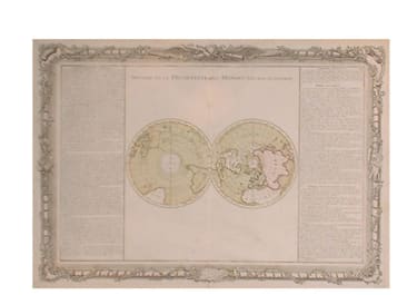
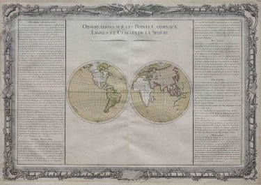
Observations Sur Les Points Cardinaux Lignes, Et Cercles De La Sphere
Sold
Very attractive double hemisphere map with text on either side describing the Cardinal Points on the compass. The lines of Latitude and Longitude. The Horizon, the Ecliptic, the Meridian and the Poles.Original colour.Expertly repaired small tear otherwise good condition.Map similar to previous desnos world map.
code : M47
Cartographer : DESNOS Louis
Date : 1761 Paris
Size : 36*53cms
availability : Sold
Price : Sold
Louis Charles Desnos (1728-1805) was a renowned mapmaker, globemaker and publisher of Paris. Throughout his considerable career Desnos worked with most of the eminent cartographers of his day. He came to control plates by Buy de Mornas, Brion de la Tour and Robert de Vaugondy amongst others and re-issued works by de Fer and Le Rouge. All this at a time when Paris could still be regarded as one of the largest centres of European map production.
Desnos first continued to work at the Hardy place in the rue Saint-Julien-le-Pauvre in Paris, but in 1757, when he became a freeman, he moved to a new place, at the sign of the Globe in rue Saint-Jacques.
From 1759 he called himself 'ingénieur-géographe et libraire du roi de Danemark'. In the 1760's Desnos extended his activities as a publisher of maps and books. Globe making became less important for him, perhaps because of the success of his main competitor Didier Robert de Vaugondy.
Desnos’ works included a wide variety of cartographic subjects. Notable works include the “Petit Atlas Elementaire …” (c.1865) and the “Atlas National Et Génèral De La France” (1790) as well as many more.