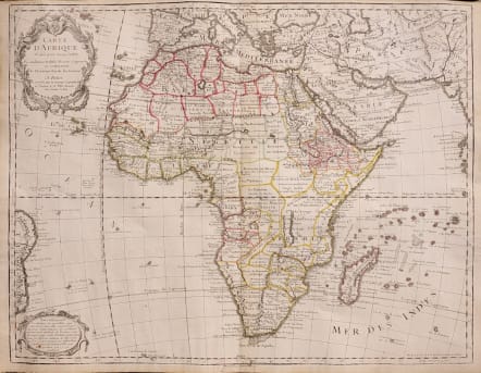
CARTE D'AFRIQUE DRESSE POUR L'USAGE DU ROY
Sold
Very Attractive map covering the whole of Africa including southern Europe and the whole of the Middle East. This is a later reissue of the famous and important De L'isle map of 1722.
Geographical knowledge in Africa was mostly garnered from a few early missionaries, sea captains and traders, who explored the coast, but had no direct knowledge of the interior. Even the great rivers of Africa were for many reasons unexplored by the whites. The huge trade in slaves, ivory, gold and other items took place at coastal forts through middle men. Not until the latter half of the 19th century did any degree of accuracy begin to appear in maps of Africa. Nevertheless, De l'Isle, characteristically, amassed a great deal of information based on reports about the continent, and some of it is in a general way true: the long thin lake north of the Zambezi corresponds to Lake Tanganyika; two source rivers join to form the Nile; and there are ranges of mountains in the southwest that go down to the Cape.
Original outline colour
Very good condition.
Moreland and Bannister, Antique Maps p. 132; Tooley's Dictionary of Mapmakers , 395.
code : M3313
Cartographer : DE L'ISLE Family
Date : 1700 / 1772 Paris
Size : 49*63 cms
availability : Sold
Price : Sold
Claude de l'Isle (1644-1720) was a geographer and historian working in Paris, but was overshadowed by his more famous son, Guillaume (1675-1726), who is probably the greatest figure in French cartography. Having learnt geography from his father, it is said that at the age of eight or nine he could draw maps to demonstrate ancient history. He studied mathematics and astronomy under J.D Cassini, where he received the grounding in scientific cartography, that is the hallmark of his work.
His first atlas was published in about 1700, in 1702 he was elected a member of the Academie Royale des Sciences, and in 1718 he became 'Premier Geographe du Roi'. His maps of the newly explored parts of the world reflect the most up-to-date information available and did not contain fanciful detail in the absence of solid information.
His work was important as marking a transition from the maps of the Dutch school, which were highly decorative and artistically-orientated, to a more scientific approach.
De L'Isle also played a prominent part in the recalculation of latitude and longitude, based on the most up-to-date celestial observations. His major contribution was in collating and incorporating this latitudinal and longitudinal information in his maps, setting a new standard of accuracy, quickly followed by many of his contemporaries. Guillaume De L'Isle's reputation was such that pirated versions appeared in many countries, most particularly by Chatelain and Covens and Mortier.
After his death in 1726 the business was continued by his nephew Philippe Buache, and subsequently by J. Dezauche.