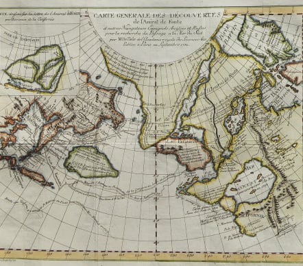

CARTE GENERALE DES DECOUVERTES DE L'AMIRAL FONTE ET AUTRES NAVIGATEURS ESPAGNOLS ANGLOIS ET RUSSES POUR LA RECHERCHE DU PASSAGE A LA MER DU SUD
£225
From Diderot's Encyclopedia ..
Much sought after map
Very interesting map of the Northwest Coast, showing De L'Isle's conjectural northwest coast, based upon De Font and Russian Discoverers, including the Bay of the West.
The map is part of the great mid-18th Century debate, from by the reports of JN De L'Isle of the Russian discoveries in the region prior to 1750, which he obtained during his time working in St. Petersburg. The debate was fed by the maps of Buache and Jefferys, which provided radically different accounts of the coast. Ulimately, the discoveries during Cook's first voyage put and end to the debate. This map tracks the voyages of Tchirikow, Frondat, Bering, and others Russians during the first part of the 18th Century and credits De Fuca, d'Aguilar and De Font with discoveries on the NW Coast. The large Sea of the West is drawn from Buache's model, with numerous other wide watercourses both through the central continent and above the arctic circle, all richly annotated with source information.
Excellent hand colour
Very good condition
An essential map for regional collectors.
code : M4160
Cartographer : DE L'ISLE Family
Date : 1772 Paris
Size : 30*38 cms
availability : Available
Price : £225
Claude de l'Isle (1644-1720) was a geographer and historian working in Paris, but was overshadowed by his more famous son, Guillaume (1675-1726), who is probably the greatest figure in French cartography. Having learnt geography from his father, it is said that at the age of eight or nine he could draw maps to demonstrate ancient history. He studied mathematics and astronomy under J.D Cassini, where he received the grounding in scientific cartography, that is the hallmark of his work.
His first atlas was published in about 1700, in 1702 he was elected a member of the Academie Royale des Sciences, and in 1718 he became 'Premier Geographe du Roi'. His maps of the newly explored parts of the world reflect the most up-to-date information available and did not contain fanciful detail in the absence of solid information.
His work was important as marking a transition from the maps of the Dutch school, which were highly decorative and artistically-orientated, to a more scientific approach.
De L'Isle also played a prominent part in the recalculation of latitude and longitude, based on the most up-to-date celestial observations. His major contribution was in collating and incorporating this latitudinal and longitudinal information in his maps, setting a new standard of accuracy, quickly followed by many of his contemporaries. Guillaume De L'Isle's reputation was such that pirated versions appeared in many countries, most particularly by Chatelain and Covens and Mortier.
After his death in 1726 the business was continued by his nephew Philippe Buache, and subsequently by J. Dezauche.