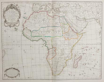
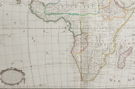

CARTE D'AFRIQUE DRESSEE POUR L'USAGE DU ROI PAR GUILLAUME DELISLE
£295
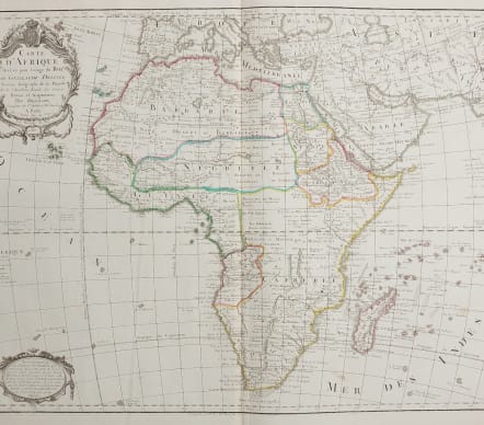
Good large folio map of Africa by De L'Isle and successors.
The map is a rare re-issue of the Delisle map of 1722. In his first map of the continent in 1700, Delisle re-measured the Mediterranean, being the first to establish its correct longitude, and thus to give a correct picture of Africa's northern coast. He was the first to discard Lake Zaire and Zaflan, as inherited from Ptolemy, and the first to show the correct source of the Blue Nile. In his revised map of 1722, Delisle adds the improvement of the depiction of Lake Myassa (Moravi). As characteristic of the period, emphasis is on the coastal area, which is well delineated. Little was known about the interior of the continent at that time, but Delisle gives interesting information about the locations of native tribes.
This is a newly engraved map after the by Delisle's successor, Phillipe Buache, map published in 1745, this map printed in 1787 with updates on boundaries etc
Lots of detail, Original outline colour depicting Kingdoms et
Tiny repaired spot near invisible
Very good condition
code : M4033
Cartographer : DE L'ISLE Family
Date : 1787 Paris
Size : 49*63 cms
availability : Available
Price : £295
Claude de l'Isle (1644-1720) was a geographer and historian working in Paris, but was overshadowed by his more famous son, Guillaume (1675-1726), who is probably the greatest figure in French cartography. Having learnt geography from his father, it is said that at the age of eight or nine he could draw maps to demonstrate ancient history. He studied mathematics and astronomy under J.D Cassini, where he received the grounding in scientific cartography, that is the hallmark of his work.
His first atlas was published in about 1700, in 1702 he was elected a member of the Academie Royale des Sciences, and in 1718 he became 'Premier Geographe du Roi'. His maps of the newly explored parts of the world reflect the most up-to-date information available and did not contain fanciful detail in the absence of solid information.
His work was important as marking a transition from the maps of the Dutch school, which were highly decorative and artistically-orientated, to a more scientific approach.
De L'Isle also played a prominent part in the recalculation of latitude and longitude, based on the most up-to-date celestial observations. His major contribution was in collating and incorporating this latitudinal and longitudinal information in his maps, setting a new standard of accuracy, quickly followed by many of his contemporaries. Guillaume De L'Isle's reputation was such that pirated versions appeared in many countries, most particularly by Chatelain and Covens and Mortier.
After his death in 1726 the business was continued by his nephew Philippe Buache, and subsequently by J. Dezauche.