
AFRICA L'AFRIQUE
£245
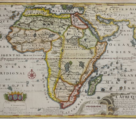
Attractive map of Africa from Introduction A La Geographie. 1717.
This map has a strange depiction of the continent with a bulge in the southwest coastline between the Cape and the Congo. Unusual islands appear in the Atlantic and Indian Oceans, including the second mythical island of St. Helena. In Central Africa there is a paragraph concerning the origin of the Nile in Abyssinia; the source of the Nile is close to correct, but the original and two mythical lakes remain. Ptolemy's lakes of Zaire and Zaflan are depicted entirely divorced from the Nile. "Monomotapa" is shown in the south and at the Cape of Good Hope there is a description about the circumnavigation by Diaz in 1486.
Excellent hand colour
Very good condition
code : M4837
Cartographer : DE FER Nicolas
Date : 1717 Paris
Size : 23*32 cms
availability : Available
Price : £245
Nicolas de Fer (1646-1720) was the son of Antoine de Fer, also a map engraver and colourist in his own right who had worked with Nicolas Berey and acted as an editor for Pierre Duval's "Cartes De Geographie ..." of 1657. However, it was Nicolas who was to become one of the most prolific publishers of his time.
De Fer was able to make the publishing business flourish and in 1690 he was nominated as geographer to the Dauphin - their relationship had reciprocal benefits with De Fer producing, in effect, royal propaganda concerning the Dauphin's lands with each publication enhancing his own name and reputation, as well as that of the Dauphin. When the Duke of Anjou ascended the throne in 1702, De Fer had the dual title of "geographe du roi d'Espagne et du Dauphin".
De Fer published a number of atlases including the "Cotes de France" of 1690 (containing Tassin's maps) and the "Forces de l'Europe ou Introduction a la fortification", also of 1690, that reinforced his abilities and success with the buying public. Subsequent publications included the "Petit et Nouveau Atlas", which appeared in 1697, followed by the "Atlas Curieux". The "Atlas Curieux" was well-known and popular, being expanded in successive editions between 1700 and 1705, and was re-edited in 1714 and 1716 under the title "Suite de l'Atlas Curieux". De Fer also produced a number of folio maps that appeared in the "Atlas ou Recueil de cartes", which was published in 1709.