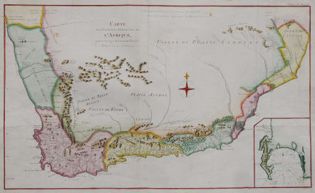
CARTE DE L’EXTEMITE MERIDIONALE DE L’AFRIQUE
£285
Carte de l'extrêmité méridionale de l'Afrique pour les voyages du lieutenant Paterson entrepris en 1777 1778 et 1779
Very scarce map of the Southern part of Africa from Cape Town to the Colony of Plettenburg. This map being the only map in Paterson’s sought after book, Quatre Voyages dans le pays des Hottentots et la Cafrerie en 1777, 1778, & 1779. First French edition 1790.
Inset plan of the Cape. Much detail not before found on maps. Especially mountains rivers and tracks.
Very decorative with compass rose etc
Good hand colour
Very good condition
Library / museum item .
Ref Bibliothèque Nationale de France. https://gallica.bnf.fr/ark:/12148/btv1b8468796h
Publication : William PATERSON. Voyages dans le pays des Hottentots, a la Caffrerie, a la baye Botanique, et dans la Nouvelle Hollande. Chez Letellier, A Paris 1790.
code : M5100
Cartographer : Benard
Date : 1790 Paris
Size : 33.5*56 cms
availability : Available
Price : £285