SUMATRA EIN GROSSE INSEL
Sold
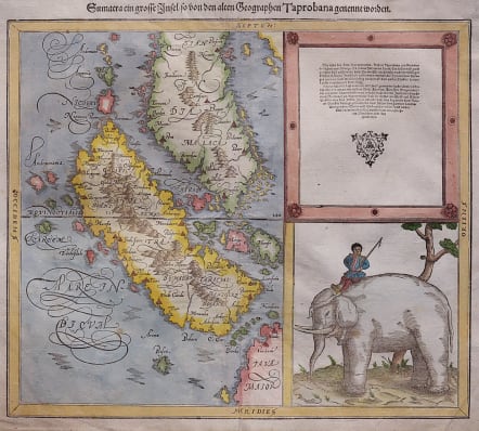
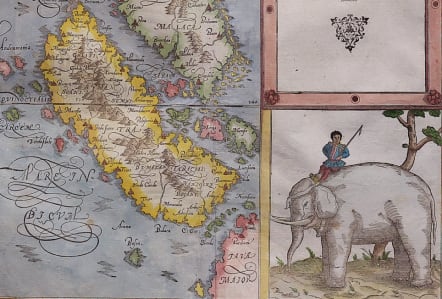
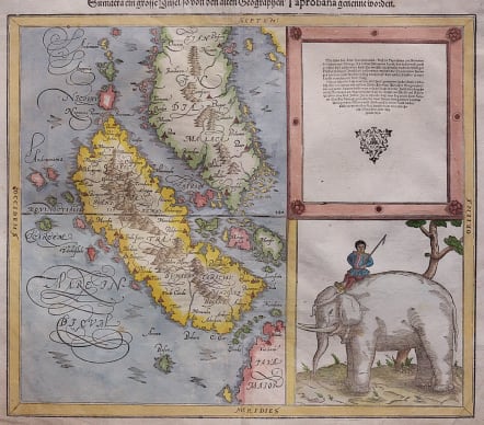
Full title: Sumatra ein Grosse Insel / so von den Alten Geographen Taprobana Genennet Worden
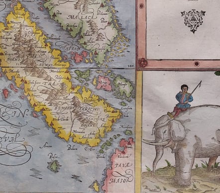
Attractive and early map of the island of Sumatra and the southern part of Malaysia. Petri's revision of the early Ptolemaic map of the same name, which confused Sumatra with the island of Ceylon.
It is one of the earliest maps to focus on this region. Near today's Singapore on the tip of the Malay peninsula is Cingafufa. Text to the right quotes Pliny, and below is a large engraving of an elephant and his mounted handler (oddly dressed in European clothes). German title and woodcut illustration on verso.
Excellent hand colour
Centre fold
Very good condition
code : M4444
Cartographer : Sebastian Munster
Date : 1578/ Basel
Size : 31**36 cms
availability : Sold
Price : Sold
Originally a scholar studying Hebrew, Greek and mathematics, Sebastian Munster (1489-1552) eventually specialised in mathematical geography and cartography. It was this double ability - as a classicist and mathematician - that was to prove invaluable when Munster set himself to preparing new editions of Solinus’ “Memorabilia” and Mela’s “De Situ Orbis”, two classical descriptive geographies containing maps, and his own two greatest works, the “Geographia” and “Cosmographia”. These reflect the widespread interest in classical texts, which were being rediscovered in the fifteenth century, and being disseminated in the later fifteenth and sixteenth century, through the new medium of printing.
The “Geographia” was a translation of Ptolemy’s landmark geographical text, compiled in about 150 AD., illustrated with maps based on Ptolemy’s calculations, but also, in recognition of the increased geographical awareness, contains a section of modern maps. In the first edition of the “Geographia”, Munster included 27 ancient Ptolemaic maps and 21 modern maps, printed from woodblocks. Subsequent editions of the “Cosmographia” were to contain a vast number of maps and plans.
One consequence of Munster’s work was the impetus it gave to regional mapping of Germany, but Munster was also the first cartographer to produce a set of maps of the four continents on separate maps. Most importantly, through his books (the “Geographia” and “Cosmographia” alone ran to over forty editions in six languages), Munster was responsible for diffusing the most up-to-date geographical information throughout Europe.