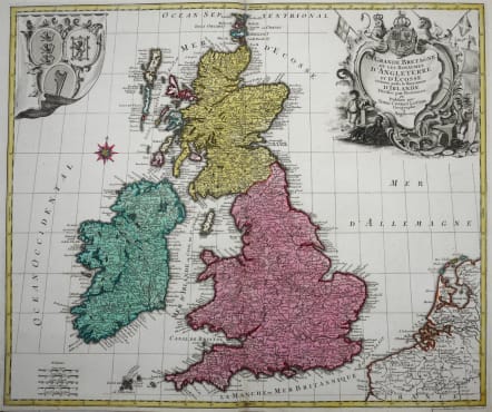
LA GRANDE BRETAGNE OU LES ROYAUMES D'ANGLETERRE ET D'ECOSSE COMME AUSSI LE ROYAUME D'IRLANDE
£325
Very attractive and mint condition map of the British Isles.
A map of the British Isles decorated with an ornate title cartouche and the arms of England, Wales & Scotland, engraved by Mathias Lotter for his father Tobias's atlas. Strong impression.
Good strong full original colour.
Beautiful condition.
Ref: Phillips (A) 3513-11.
code : M2899
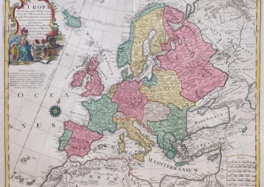
Cartographer : LOTTER Conrad
Date : 1764 Augsberg
Size : 49*58 cms
availability : Available
Price : £325
The Lotter family were and engraves and publishers based in Augsburg with a prolific output of maps in the eighteenth century.
Tobias Conrad Lotter (1717-1777) worked with Georg Matthaus Seutter (his father-in-law - he married Georg's daughter in 1740) and Tobias Lobeck. In 1756 he succeeded his father-in-law jointly with Albrecht Seutter's son and Georg Balthasar Probst, also re lated by marriage. In 1758 Lotter inherited half the copperplates of the Seutter firm and was able to set up his own, independent publishing house that same year. Some of his best known atlas works are the "Atlas Minor" (c.1744), the "Atlas Der Ganzen Welt" (1748) and the "Atlas Novus" (c.1770), as well as numerous, important, single map - the "REcens Edita Totius Novi Belgica" of c.1760 being just one of note.
The Seutter/Lotter collaboration was recognised as one of the great German publishing endeavours of the eighteenth century.
Tobias Conrad was succeeded by his sons Matthaus Albrecht Lotter and Georg Friedrich Lotter, and other family members were also involved.