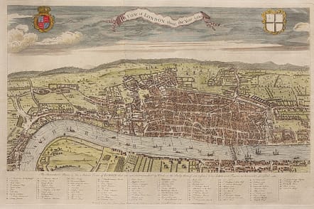
A VIEW OF LONDON ABOUT THE YEAR 1560
Sold
Highly detailed bird's-eye view of London shows the city circa 1560 with many important places named in the view. The plan was reduced from the Civitas Londinum attributed to Ralph Agas. Locates the London Bridge, the Tower, St. Katherines, Smyth Field, as well as naming most streets including Fleet, the Strand and Cheapside. The alphanumeric key along the bottom locates another 95 important buildings and places of interest. The title is carried in a ribbon-style cartouche in the sky with coats of arms to either side. The imprint at bottom is dated 1738 and it was published as the frontispiece to Vol. I of The History of London by William Maitland, circa 1754.
Beautiful hand colour.
Mint condition.
Ref: Howgego #8 (b).
code : M3369
Cartographer : Maitland Toms
Date : 1754
Size : 31*48 cms
availability : Sold
Price : Sold