


EUROPAE
£0
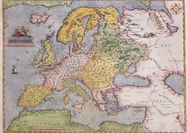
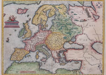
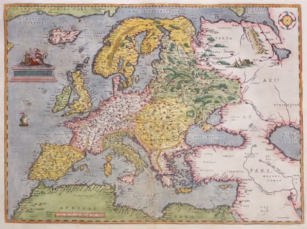
Superb example of the first state of Ortelius' map of modern Europe.
(Date of the first edition: 1570. Date of this map: 1574.)
This highly decorative map depicts the continent as it was known in the 1570’s. Topographical features are shown and countries, major cities, towns, waterways, forests and islands are located. The small title cartouche on the upper left side depicts Europa on Zeus the Bull.
The map is updated to the latest information, based upon several important maps of Europe, including Gerard Mercator's 1554 map of Europe; the mapping of Greenland and Iceland from Mercator's 1569 world map. The treatment of Great Britain is based upon Mercator's 1564 Great Britain map. Scandinavia is drawn from Olaus Magnus' 1539 Scandinavia map. Russia is based on Jenkinson's 1562 Russia map. The Southeastern part of this map is based upon Gastaldi's 1559 map of Asia. Parts of the North African coast are based upon Gastaldi's Africa map of 1564.
Latin text
Excellent hand colour Full clean margins
Very good condition for this sought after map of early copper engraved map of Europe
Publication Theatrum Orbis Terrarum. 1574
References: Van der Krogt 3 - Van den Broecke - 4 (First plate); Karrow - 1/10 Africa is still in block letters
1200
SOLD
code : M5336
Cartographer : Ortelius Abraham
Date : 1573 Antwerp
Size : 34.5*46.5 cms sheet 44.5*58 cms
availability : Available
Price : £0
From about 1560, possibly as a result of his friendship with Mercator, Ortelius began to produce maps - an eight sheet world map being the earliest. At this time, Ortelius also began preparing his greatest project, the Theatrum Orbis Terrarum. Having already become probably the greatest cartographic bibliographer of the period, Ortelius was able to prepare 53 map sheets based on the most up-to-date information, which were engraved by Frans Hogenberg, and first published in 1570.
The atlas achieved instant fame as "the world's first regularly produced atlas" (Skelton), being the first atlas with maps prepared to a uniform format. It was also an immediate commercial success, being reprinted four times in 1570. . Over 30 different editions, with text in Latin, French, Dutch, German, Italian, English or Spanish, testify to the popularity and esteem attributed to the work. Marcel Van Den Broecke, whose fascinating work on Ortelius and his maps is often quoted, estimates that around 7300 complete atlases were published using a total of 234 copperplates, either replacements or reworkings as plates became out-dated, worn, or as new information became available. Amongst this latter category, the maps added in the 1580's and 90's of the world, the Americas, China, the Pacific, Japan, Peru and Florida, and Iceland are important historically and justly famous.The maps themselves are finely engraved, often very decorative and generally found with text on the reverse.
After Ortelius' death in 1598 the atlas continued to be printed and published by the Plantin Press. Between 1602 and 1609 it was published by Johann Baptist Vrients, who added a variety of fine maps including the very decorative large plates of England and Wales, and of Ireland. Publication reverted to the Plantin Press, under the control of the Moretus brothers, from 1612.
Although only the relatively unsuccessful atlases of De Jode and, ultimately, Mercator were published during the sixteenth century life of the Theatrum …, in 1607 Jodocus Hondius's issue of Mercator's Atlas ... with many newly prepared maps began to supersede Ortelius' work.
Ortelius's small Atlas The Epitome published from 1590 ran for many editions and was very popular.