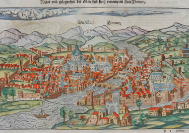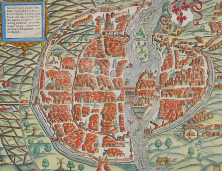


DIE STATT PARIS
£650
Superb example of Munster's early birdseye view of Paris. This is Munster's first edition but second issue plan of Paris. Well engraved with each individual house marked.
Includes a coat of arms and illustrates the town in remarkable detail, including buildings, bridges, the fortified walls of the city and other landmarks within the walls of the city, with farms, windmills etc in the countryside.
The map shows the wall of Philippe Auguste, destroyed between 1529 and 1535, the tower of Billy destroyed by fire in 1538. The map extends from the abbaye Saint Antoine and the Faubourg St Marcel in north, to Montmartre and the gibet of Montfaucon in west, to the Faubourg Saint-Honoré and the gibet of St Germain-des-Pres in south, and the moulin of Gobelins, the Cordelières rue de Lourcine.
One of the earliest attainable views of Paris. From Munster's Cosmographia, one of the most influential works of the 16th Century.
Predates the Braun & Hogenberg of Paris.
In right bottom corner, the initials of the engraver: HR MD (Hans Rudolf Manuel Deutsch) followed by a dagger places horizontally.
Excellent professional hand colour
Mint condition
Ref : Les Plans de Paris Jean Boutier Page 79 Map of Paris Number 5 1550-1575 5iiib
code : M5097
Cartographer : Sebastian Munster
Date : 1550/+ Basel
Size : 25.5*36 cms Sheet 31*39 cms
availability : Available
Price : £650
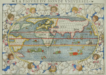
Originally a scholar studying Hebrew, Greek and mathematics, Sebastian Munster (1489-1552) eventually specialised in mathematical geography and cartography. It was this double ability - as a classicist and mathematician - that was to prove invaluable when Munster set himself to preparing new editions of Solinus’ “Memorabilia” and Mela’s “De Situ Orbis”, two classical descriptive geographies containing maps, and his own two greatest works, the “Geographia” and “Cosmographia”. These reflect the widespread interest in classical texts, which were being rediscovered in the fifteenth century, and being disseminated in the later fifteenth and sixteenth century, through the new medium of printing.
The “Geographia” was a translation of Ptolemy’s landmark geographical text, compiled in about 150 AD., illustrated with maps based on Ptolemy’s calculations, but also, in recognition of the increased geographical awareness, contains a section of modern maps. In the first edition of the “Geographia”, Munster included 27 ancient Ptolemaic maps and 21 modern maps, printed from woodblocks. Subsequent editions of the “Cosmographia” were to contain a vast number of maps and plans.
One consequence of Munster’s work was the impetus it gave to regional mapping of Germany, but Munster was also the first cartographer to produce a set of maps of the four continents on separate maps. Most importantly, through his books (the “Geographia” and “Cosmographia” alone ran to over forty editions in six languages), Munster was responsible for diffusing the most up-to-date geographical information throughout Europe.