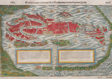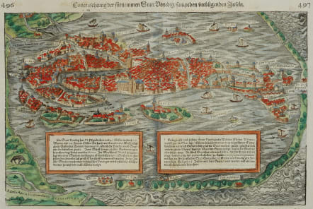

VENICE CONTRASCHTUNG DER FURNEMEN STATT VENEDIG
Sold
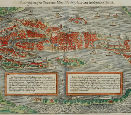
Contraschtung der fürnemen Statt Venedig / sammt den umliigneden Inseln
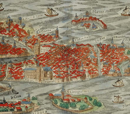
Stunning 1550's bird's-eye view of Venice depicting the historic city of Venice within the Venetian Lagoon. One of the earliest obtainable birds-eye views of Venice.
Rendered beautifully to contrast the calm shallow lagoon with the turbulent seas beyond the sand banks, the view depicts the sestiere of Venice and includes two text blocks describing the city and its history. The generalized style of many of the buildings allow finer architectural detail in churches, buildings, and city walls to stand out. A few sail boats can be seen in the waters.
Excellent hand colour ..
Mint condition
code : M5053
Cartographer : Sebastian Munster
Date : 1550c Basel
Size : 24.5*38 cms
availability : Sold
Price : Sold
Originally a scholar studying Hebrew, Greek and mathematics, Sebastian Munster (1489-1552) eventually specialised in mathematical geography and cartography. It was this double ability - as a classicist and mathematician - that was to prove invaluable when Munster set himself to preparing new editions of Solinus’ “Memorabilia” and Mela’s “De Situ Orbis”, two classical descriptive geographies containing maps, and his own two greatest works, the “Geographia” and “Cosmographia”. These reflect the widespread interest in classical texts, which were being rediscovered in the fifteenth century, and being disseminated in the later fifteenth and sixteenth century, through the new medium of printing.
The “Geographia” was a translation of Ptolemy’s landmark geographical text, compiled in about 150 AD., illustrated with maps based on Ptolemy’s calculations, but also, in recognition of the increased geographical awareness, contains a section of modern maps. In the first edition of the “Geographia”, Munster included 27 ancient Ptolemaic maps and 21 modern maps, printed from woodblocks. Subsequent editions of the “Cosmographia” were to contain a vast number of maps and plans.
One consequence of Munster’s work was the impetus it gave to regional mapping of Germany, but Munster was also the first cartographer to produce a set of maps of the four continents on separate maps. Most importantly, through his books (the “Geographia” and “Cosmographia” alone ran to over forty editions in six languages), Munster was responsible for diffusing the most up-to-date geographical information throughout Europe.