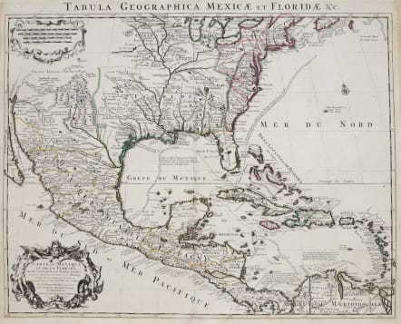
CARTE DU MEXIQUE ET DE LA FLORIDE DES TERRES ANGLOISES
£895
Beautiful example of Coven's & Mortier's edition of the first printed map to accurately depict the course and mouth of the Mississippi River.
Covens & Mortier's map is based upon De L'Isle's Carte du Mexique, which was drawn from the reports brought back to France from the survivor's of the La Salle expedition into the interior of North America and from information derived from the explorations of Bienville and d'Iberville.
De L'isle map is an important map on the development of the mapping of America. . De L'Isle's map also includes greater accuracy in the Great Lakes region and in its depiction of English settlements along the East Coast. Excellent detail of the Indian villages in East Texas, based upon the reports of Iberville and the Spanish missionaries. The best depiction of the Southwest to date, w/ early trails & Indian tribes. Cumming described the map as profoundly influential.
Original outline colour.
Near mint condition.
Ref: Martin & Martin, Maps Of Texas And Southwest, cf. pp.92-93.
code : M2957
Cartographer : DE L'ISLE Family
Date : 1708 / 1722 Amsterdam
Size : 49*62 cms
availability : Available
Price : £895
Claude de l'Isle (1644-1720) was a geographer and historian working in Paris, but was overshadowed by his more famous son, Guillaume (1675-1726), who is probably the greatest figure in French cartography. Having learnt geography from his father, it is said that at the age of eight or nine he could draw maps to demonstrate ancient history. He studied mathematics and astronomy under J.D Cassini, where he received the grounding in scientific cartography, that is the hallmark of his work.
His first atlas was published in about 1700, in 1702 he was elected a member of the Academie Royale des Sciences, and in 1718 he became 'Premier Geographe du Roi'. His maps of the newly explored parts of the world reflect the most up-to-date information available and did not contain fanciful detail in the absence of solid information.
His work was important as marking a transition from the maps of the Dutch school, which were highly decorative and artistically-orientated, to a more scientific approach.
De L'Isle also played a prominent part in the recalculation of latitude and longitude, based on the most up-to-date celestial observations. His major contribution was in collating and incorporating this latitudinal and longitudinal information in his maps, setting a new standard of accuracy, quickly followed by many of his contemporaries. Guillaume De L'Isle's reputation was such that pirated versions appeared in many countries, most particularly by Chatelain and Covens and Mortier.
After his death in 1726 the business was continued by his nephew Philippe Buache, and subsequently by J. Dezauche.