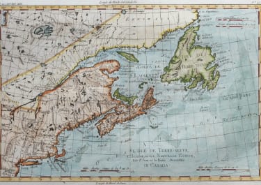
PARTIE DU NORD DE L'AMERIQUE SEPTENTRIONALE
£125
This attractive map of the eastern part of North America shows the British colonies confined along the eastern seaboard with French Louisianne and Canada taking up the interior. In the upper left is a series of rivers and lakes purportedly connecting Hudson Bay with "la Mer de l'Ouest" (Sea of the West). Features include the notation of the Natchitoches tribe in Louisiana Territory, along with numerous additional native tribes. Three distance scales and a fine shield-style cartouche embellish the composition. No engraver's imprint on this edition.
Good Hand colour
Very good condition
Publication Publication: Raynal's Histoire Philosphique et Politique
Ref: McCorkle #774.1.
code : M3841
Cartographer : BONNE Rigobert
Date : 1774 Paris
Size : 32*24 cms
availability : Available
Price : £125
Rigobert Bonne (1727-1795), a prolific French cartographer, was active between about 1760 and 1788, working in the French Hydrographical Office, and appointed as Hydrographer to the French King.
Bonne prepared a large number of charts, some of which appeared in the Atlas Maritime. Today, he is best known for the smaller maps that he prepared for Raynal’s Atlas de Toutes Les Parties Connues du Globe Terrestre, published in 1780, and the Atlas Encyclopedique, published in conjunction with Nicholas Desmarest. Although the maps are relatively plain, dispensing with the decorative embellishment of mid-century, they are detailed and provide good coverage of newly discovered regions.