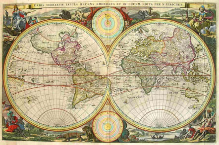
ORBIS TERRARUM TABULA RECENS EMENDATA ET IN LUCEM EDITA PER N VISSCHER
Sold
Superb example of the first state double hemisphere map of the world, which includes many of the great 17th Century cartographic errors. A massive land extension north of California reaches nealy to Asia and shows the Straits of Anian and NW Passage, with dozens of early place names on the NW Coast, including Quivira Regnum, which appears twice. North America is misconfigured in a manner similar to early world maps by Hondius. A partial New Zealand and Australia both appear. The tracks of Magellan's circumnavigation are shown, along with other cartographic misconceptions. cartography. Four allegorical female figures represent the four continents (Europe, Asia, America and Africa), along with exotic allegorical scenes. Two celestial models are shown center top and bottom.Superb early full color example, with wide margins and no restorations. Shirley 431. NOT to be confused with the later and more numerous Second edition of 1677 or the even later Stoopendaal reissue. SOLDcode : M1195
Cartographer : Nicolaas VISSCHER
Date : 9000./ .1663 Amsterdam
Size : 31*47.5cms
availability : Sold
Price : Sold
Among the many great Dutch map publishers active in the seventeenth century were the Visscher family; the firm was begun by Claes Jansz Visscher (1587-1652), and subsequently included his son Nicolaas (1618-1679), grandson Nicolaas II (1649-1702) and then his grandson’s widow, Elizabeth, until her death in 1726.
Although mainly art dealers, the Visschers were prolific publishers, producing individual maps and also atlases made up to their customers’ specifications. Indeed, they are commonly regarded as second only to the Blaeus among Dutch map-makers for the high quality of engraving and decoration and the geographical accuracy of their many maps. Particularly outstanding - not only as maps but as works of art - are their world maps.


