MUNSTER'S SEA MONSTERS MEERWUNDER UND SELZAME
Sold
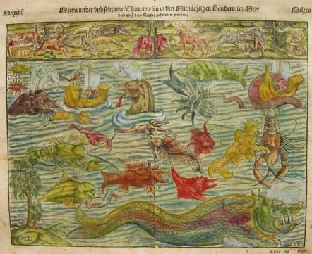
Remarkable chart of mythical land and sea monsters and other creatures, from Munster's Cosmographia, one of the most influential works of the 16th Century.
Munster's plate of mythical creatures is taken from Olaus Magnus' Carta Marina of 1539 and includes abundant tusks, horns and twin-spouts. One vignette shows a galleon trying to outrun one monster by throwing their cargo overboard, while one sailor takes sight with a musket. Ortelius also adapted many of the monsters for use on his map of Iceland in 1587. One of the most sought-after of all 16th Century curiosities.
Very good condition.
code : M2369
Cartographer : Sebastian Munster
Date : 1550/+ Basle
Size : 27.5*35cms
availability : Sold
Price : Sold
Originally a scholar studying Hebrew, Greek and mathematics, Sebastian Munster (1489-1552) eventually specialised in mathematical geography and cartography. It was this double ability - as a classicist and mathematician - that was to prove invaluable when Munster set himself to preparing new editions of Solinus’ “Memorabilia” and Mela’s “De Situ Orbis”, two classical descriptive geographies containing maps, and his own two greatest works, the “Geographia” and “Cosmographia”. These reflect the widespread interest in classical texts, which were being rediscovered in the fifteenth century, and being disseminated in the later fifteenth and sixteenth century, through the new medium of printing.
The “Geographia” was a translation of Ptolemy’s landmark geographical text, compiled in about 150 AD., illustrated with maps based on Ptolemy’s calculations, but also, in recognition of the increased geographical awareness, contains a section of modern maps. In the first edition of the “Geographia”, Munster included 27 ancient Ptolemaic maps and 21 modern maps, printed from woodblocks. Subsequent editions of the “Cosmographia” were to contain a vast number of maps and plans.
One consequence of Munster’s work was the impetus it gave to regional mapping of Germany, but Munster was also the first cartographer to produce a set of maps of the four continents on separate maps. Most importantly, through his books (the “Geographia” and “Cosmographia” alone ran to over forty editions in six languages), Munster was responsible for diffusing the most up-to-date geographical information throughout Europe.